OUCC Proceedings 11 (1983)Some Karst near Oxford |
OUCC Proceedings 11 Contents |
Martin Laverty
To most Oxford cavers, Cumnor Hill is the bleary-eyed, early morning prelude to a Mendip caving trip. Few realise that it is Oxford's nearest karst area, with sinking streams, dolines and springs. Fewer care.
From the sporting point of view, this is not unreasonable, but it is surprising that little scientific work has been done there as Oxford has something of a reputation as a centre of karst studies.
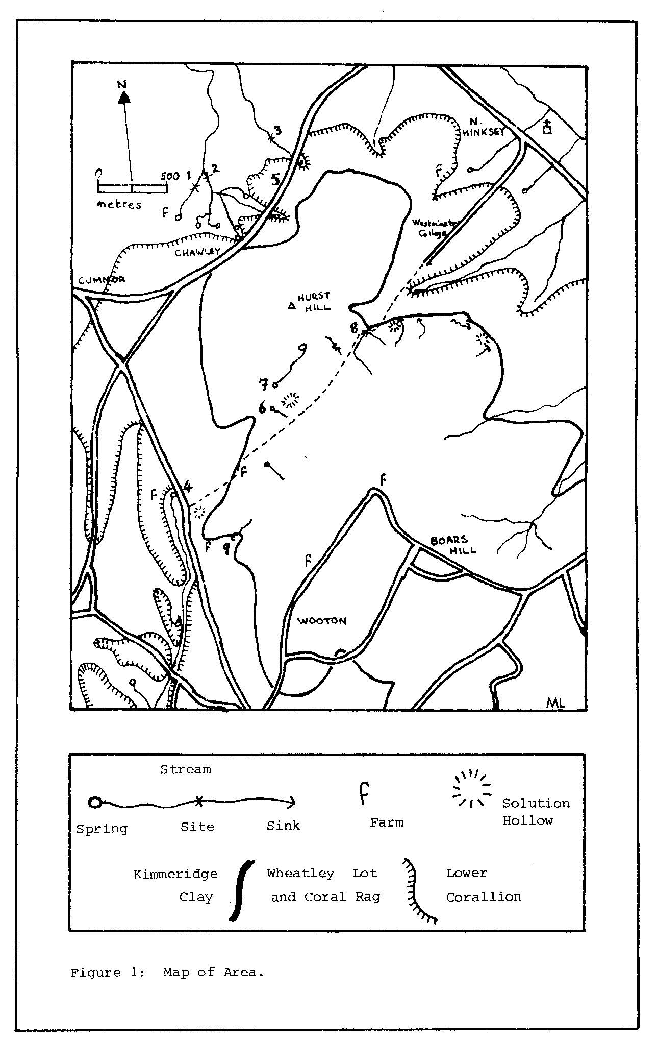
The most obviously karst features of the area, the sink or 'swilly' (or gully) holes, are referred to by the brewery-owning geologist Arkell (1947), and more detailed references to the area are given by both Craven and Sanders in the Craven Pothole Club Journal for 1965 and in OUCC's own Proceedings (1966). Since the publication of these articles, more digging was undertaken by OUCC in the mid-sixties, which is now filled in and covered by a bridge, and I did some limited water analysis which is reported here and assisted digging operations started by Richard Rose, a Mendip caver, and continued with no real success by OUCC in the late seventies. It is hoped that this article might prompt someone to carry on with the chemical observations, perform dye tracing, and make other hydrological observations before the economics of modern farming dictate the complete obliteration of the natural karst order here. The area to the N of Oxford at North Leigh has suffered already.
The limestone in which the karst is developed is known as the Coral Rag, a shelly reef limestone of Corallian (Jurassic) age. Analysis of one sample showed it to be very pure, with only 0.09% insoluble residue, with a fairly high Fe/Mn ratio which probably accounts for its yellowish colour, and high Sr as a result of incorporation of aragonitic shells. Development of karst features seems to be along joints.
There are a number of sites identified on the map (Figure 1), which is identical to the one in Sanders (1966) except for the addition of new sites at:
| Springs: | (i) | Water seeps out of sand into a boggy area and collects into a stream which drops over a small waterfall into a pool. Water was sampled at the fall, where tufa deposition on twigs and leaves is evident. |
| (ii) | Another boggy spring. | |
| (iii) | Yet another boggy spring. | |
| (iv) | A spring capped by the Thames Water Board. | |
| Well: | (v) | In the front garden of no. 72 Cumnor Hill (Hidsfield House). Not descended, although descent might be interesting. |
| Sinks: | (vi) | Pothole dug to about 3 m depth with rift to S taking water when dammed. |
| (vii) | Sink under large tree which backs up by several metres in flood. | |
| (viii) | Sink under bridge crossed by track referred to as dug in '60s. Further details, including photos, are rumoured to be in possession of the farmer. | |
| (ix) | Prominent sink in depression in field which backs up to form a large pool in floods. |
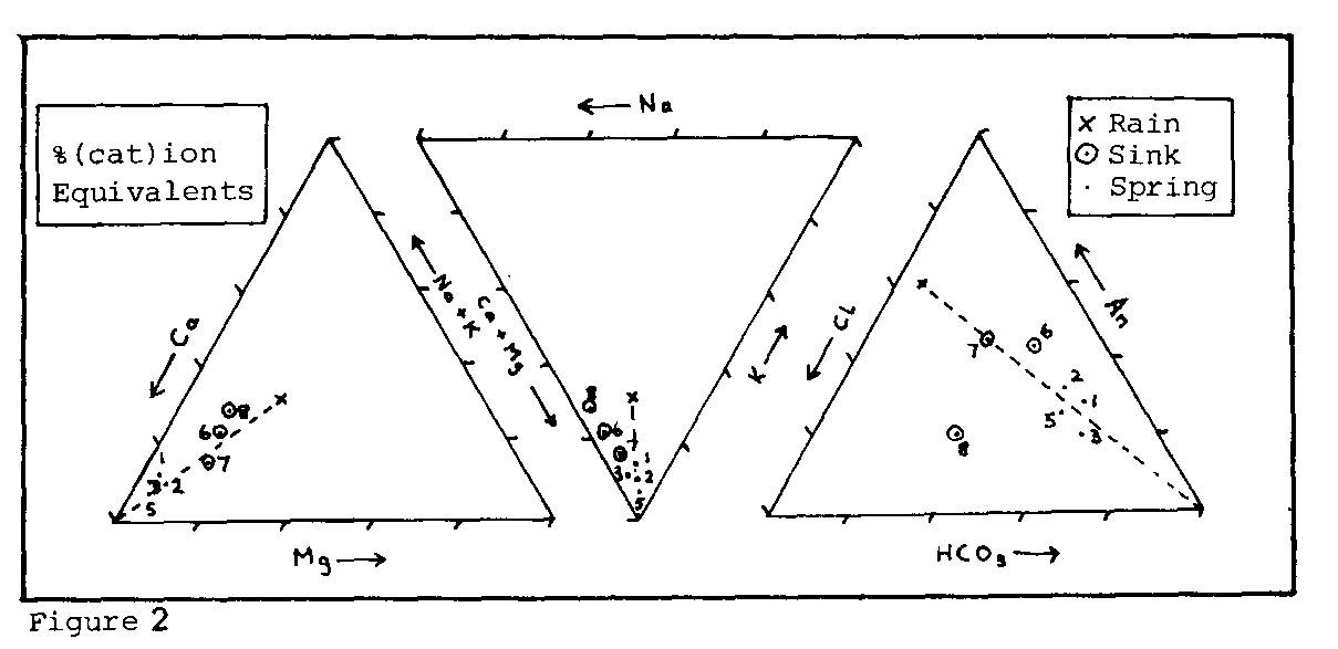
Triangular graphs (Figure 2) show the composition of the waters quite well, and permit general trends in their chemical evolution to be seen. One rainwater sample which was collected in Oxford itself is included. Clearly (provided you are familiar with trilinear plotting!) the main trend is the enrichment of the waters in Ca and HCO3 ions from rain to sink to spring.
The sinks were notably more acid than the springs (6.0-7.1 against 7.4-8.0), with the highest pH during dry periods, as would be expected.
| Sinks | Springs | Well | Units | |
| Ca | 114-207 | 317-425 | 448 | ppm CaCO3 |
| Mg | 25-41 | 6-32 | 20 | ppm CaCO3 |
| K | 4-6 | 2-27 | 1 | ppm K |
| Na | 12-32 | 15-22 | 11 | ppm Na |
| HCO3 | 55-140 | 281-311 | 290 | ppm CaCO3 |
| Cl | 37-60 | 41-61 | 68 | ppm Cl |
| Si | 3.9-7.3 | 9-1.3 | 1.7 | ppm Si |
The sinks are aggressive whereas the springs are saturated. Specific values are not given as they are not easily reproducible unless continuous shaking and temperature control are employed. They weren't used in this case, as the samples were used to investigate the effect of shaking. This is a point not brought out in references in the caving literature to aggressiveness measurement.
Using the ratio of ultraviolet absorption at 400 nm to that at 600 rim (the E4/E6 ratio) the nature of the organic matter can be compared with values from soils in other areas. In the latter respect, the value of ca. 2 compares to ca. 5 for the W Kingsdale System, and is lower than any of the values quoted for soils by Kononova (1966). This could be an agricultural effect.