OUCC Proceedings 11 (1983)Borneo 1983 - The Caves |
OUCC Proceedings 11 Contents |
Martin Laverty
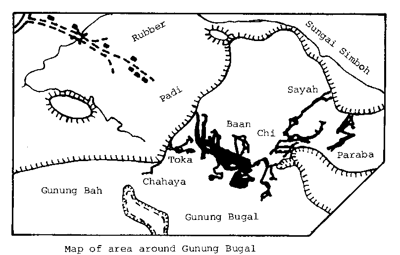
Map of the caves of Bunung Bugal (Tangs Baan, Chi, Toka, Sayah, Paraba, Chahaya)
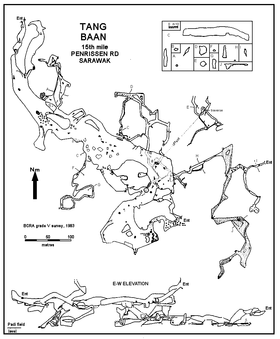
This cave has a somewhat colourful recent history. During the 1970s a group of Communist terrorists is said to have hidden in this cave for almost a year. The story seems true as the only site suitable for a camp has a five-pointed star drawn on a nearby boulder. We stayed there and can attest to its comfort. Their stay was terminated by the security forces machine-gunning them as they left the cave. Another group fared somewhat better, but almost died of thirst when they were stranded in the cave for four days by light failure. Fortunately, our guide came out of retirement to find them and take them to one of the few water sources. The confusing nature of the large passages-cum-chambers may have contributed to this - of 6412 m which we surveyed, 609 m consisted of totally unexpected resurveys following almost exactly the same lines in large chambers!
All three entrances are hard to find, the most obvious being the least accessible. The other two are small, but draught strongly and quickly open out inside. The jungle-hidden entrance is only about 5 m x 1 m, a little slit in a steep slope. As you move through the cave, however, the dimensions increase so that at the 'Magic Pool' it is about 70 m across and 15 m high. This pool is a curious feature. In the middle of this huge cavern is a small mound on the top of which are three 0.6 m diameter pools ringed by crystals glued together. The water is very clear, and unlike all the other water in Borneo caves is not obviously infested. We saw only one small crab in it. The magic part is that no drips seem to fall into the pool, and we were told that it remained full in all seasons - '100 men drink, no empty'. Our sprightly 69-year-old guide who told us this went on to make a sacrifice at a cleft in the rock nearby which forms a convenient altar.
The half-Chinese guide who showed us the way into Baan didn't really let us take in the beauty of the place. Only when we surveyed it and explored later did we find the fabulous formations and huge chambers. He had led us along a path which followed one wall of a chamber which turned out to be 450 x 150 metres and about 20 m high. The chamber is divided up by impenetrable walls of stalagmites but there is no escaping the frightening size. The largest bit encompassable in a single view is 100 m x 100 m, which is big enough for me. Squeezing through the gap at the far end of this chamber leads you into one of the other entrances in the middle of the jungle. The locals have erected traps here to catch the birds and bats and, no doubt, make them into soup as well. Many side passages run off this huge chamber, but the route right through to the other side of Ounong Rumbang is so obscure it is impressive that the locals found it. On the way the route passes the most beautiful of the formations the group saw in Borneo; it is an 8 m high perfectly white stal column, probably the only clean thing in the whole cave. The best thing about this column is that it rises out of a pit below you, and is so close to the ledge from which you view it that no photo can ever capture it. Perhaps that's just as well.
Several main types of passage are traversed in the cave: large phreatic rifts aligned along joints; steep phreatic tubes; wide and/or muddy passages which evidently flood (probably backflooding from the surface); wide phreatic passages/chambers with extensive breakdown; small phreatic tubes. There is an almost total lack of clear vadose features.
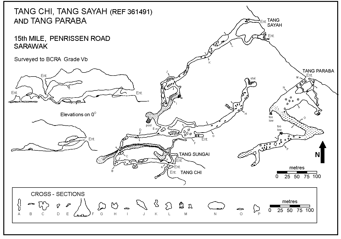
Tang Sungei is a small stream cave running near the base of the limestone cliffs on the E side of the hill. It has two entrances over cliff-foot boulder falls and down mudslopes, and leads to a dry passage with an aven which probably connects to Chi, which is entered about 50 m up the cliff and reached by an obscure route. The cave contains a 10 m pitch (once rigged with lianas!) and several climbs and leads to two entrances on the W of the hill, one of which is named Saya.
Surveyed by Wilford (1964); our survey agrees in most respects except for the final section of passage.
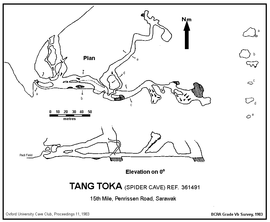
Named after a huge spider living in a hole near the large entrance which is only a little above the padi field. The entrance appears to be a shell midden. Several sumps are found inside. The cave also contains much wildlife - suffice it to say that on a surveying trip in this cave one of the party was taken short and dashed up a side passage with the bog roll. Only two hours later, when the party reluctantly returned to this passage to survey it there was absolutely no trace left of the deed!
The following caves are said to be in the Bunuk area and more or less regularly visited by bird's nest collectors:
Suira, Jeol (1 and 2), Mudik, Bai (1 and 2), Tibua, Kebuak, Banti, Keyuak, Menjog, Tiang, Duh, Rasan Kambah, Bayur, Sakuah, Nggang Pasun, Bai Rlnyo, Minggu.
On the 1:50,000 map (Munggu Babi sheet 1-110-10), several closed depressions are evident on the limestone hills north of Bunuk. In particular, we decided to visit those on G Penyok. The new geological map shows that these are particularly interesting because they are formed at the junction of limestone with weathered volcanics. True to the textbook, the lower junction was found to be dotted with small sinks. Most were inaccessible, choked shafts, but one gave access to a clean-washed and distinctly vadose sink cave, the first such cave to be surveyed in Borneo. A short pitch dropped into a passage leading to a 10 m pitch into a pool, whence a reticulate set of joint controlled passages led to a low duck, which sumped. Above the pitch, a route led to a larger upper set of chambers more typical of Borneo which were more easily reached from outside.
The largest single limestone block in the Bau-Serian outcrop is located here and has considerable potential. Wilford (1964, 89-96) surveyed three caves here, and the geological map shows some interesting alluvium- floored closed depressions on the top of the hill, complete with a stream. It is surprising that Wilford makes no further mention of these features.
A night spent in the Islamic longhouse of Blimbin gave rise to the following list of caves (cave=dang in the dialect here) known to the villagers:
Sibandir, Pangir (A and B), Singau, Payang, Paiit (A and B), Bung Ayak, Ketak, Spai and Sidug, Batu Sapug, Sekat, Cite, Bait.
Batu Sapug was said to be the largest cave, a visit taking two hours in and two hours out. It is presumably the same cave as Wilford (1964) surveyed to a short drop and recorded as Batu Sempok.
The Bidayuh longhouse village by the river at Temurang is occupied by many people who moved down from the abandoned village site at Braang Wah. We visited three caves here, one being a large resurgence. A very large closed depression near the site of Wah was not entered as a return was intended but never made. The base of the limestone is at about 300 m here and the Temurang resurgence is only at about 60 m, so a reasonable depth potential may be attainable, perhaps in vadose passage. The area is very promising and begs further investigation.
A steep climb up an obscure path emerges about 50 m up into a descending entrance to a large passage some 30 m high. Perhaps 100 m of cave leads to a steep upwards sloping entrance. A pitch was left undescended but could be the key to passages behind the resurgence.
Water emerges from sumped rifts to flow shortly into the Sungei Sarawak Kin, here called the S Semadang. However, about 5 metres above there is a large phreatic tube which is a flood rising and allows the main stream to be seen emerging from more flooded rifts into a moderate-sized chamber. There may be possibilities for extension in higher-level rifts, some of which seemed to draught, and perhaps also connect with higher entrances.
Reached by a climb up a path of notched logs, this cave draughted quite strongly through rifts at the end, about 100 metres in.
Bait, B., 1980. Stratigraphic and Petrographic Studies of the Bau Limestone, W Sarawak, Malaysia. Unpublished thesis.
Bull, P.A. & Laverty, M., 1981. Cave sediments. In Eavis, A.J. (ed.) Caves of Mulu '80. Royal Geographical Society, London, 47-49.
Bull, P.A. & Laverty, M., 1982. Observations on Phytokarst. Z. Geomorph. N.F. 26, 437-457.
Coo, J.C.H. & Lau, J.W.E., 1977. Recognition of Reef Facies in the Bau Limestone. Geol. Pap. geol. Surv. Malaysia 2, 72-78.
Everett, A.H., 1878. Volcanic phenomena in Borneo. Nature Lond. 17, 200- 201.
Everett, A.H., 1879. Second quarterly report on the Bornean cave exploration. Rep. Br. Ass. Advmt Sci. 49, 149-155.
Everett, A.H., 1880. Report on the exploration of the Bornean caves in 1878-9. Proc. R. Soc. 30, 310-319.
Harrisson, T., 1961a. Niah Caves project: 1961 on? Sarawak Gazette 1235, 3-4.
Harrisson, T., 1961b. Niah excavations: progress in 1961. Sarawak Gazette 1240, 98-100.
Harrisson, T., 1965. Histoplasmosis in Sarawak. Sarawak Gazette 1285, 99-100.
Harrisson, T., 1968. Sarawak Gazette Feb 29, 29.
Harrisson, T., 1972. The Borneo stone age in the light of recent research. Sarawak Museum Journal 20, 385-412.
Hon, V., 1972. The Kuap Area Sheet 1-110-10 Area C. Ann. Rep. geol. Surv. Malaysia 1971, 166-170.
Non, V., 1973. Kuap Area Sheet 1-110-10. Ann. Rep. geol. Surv. Malaysia 1972.
Jantan, A., 1969. Geology of the Kpg Benuk Area, Sarawak. Unpublished thesis.
Keppel, H., 1846. The Expedition to Borneo of HMS Dido for the Suppression of Piracy. London, 2 vols.
Kirk, H.J.C., 1963. Pliocene and Quaternary Volcanic Activity in British Borneo. Bull. Br. Borneo geol. Surv. 4, 137-142.
Laverty, M., 1982. Cave minerals in the Gunung Mulu National Park, Sarawak. Cave Science 9, 128-133.
Low, H., 1848. Sarawak. Richard Bentley, London.
Matthews, L.H., 1981. Putdown Man (10). The Missing Links. New Scientist 91, 26-28.
Mundy, R., 1848. Rajah Brooke's Journals. London, 2 vols.
St John, S., 1862. Life in the Forests of the Far East. Smith, Elder & Co., London. 400 + 420 pp.
Wilford, G.E., 1963. Limestone cave formation in Sarawak & N Borneo. Bull. geol. Surv. Borneo Region Malaysia 4.
Wilford, G.E., 1964. The geology of Sarawak and Sabah Caves. Bull. geol. Surv. Borneo Region Malaysia 6, 181 pp.
Wilford, G.E. & Kho, C.H., 1965. Penrissen Area, W Sarawak, Malaysia. Rep. geol. Surv. Borneo Region Malaysia 2.
Wolfenden, E.B., 1965. Bau mining district, West Sarawak, Malaysia Part I: Bau. Bull. geol. Surv. Borneo Region Malaysia 7(1), 147 pp.