OUCC Proceedings 6February 1974 |
OUCC Home Page |
The editor of Proceedings No. 5 expressed the hope that the next number would not be forthcoming for some time. A combination of circumstances has ensured that this has in fact been the case: over four years have elapsed since the previous issue.
Less desirable perhaps is the change of contents reflected in this edition, which is devoted entirely to the report of the 1971 Oxford University Gave Club expedition to Northern Spain. Editorial difficulties and lack of money have precluded an earlier publication of the report. The first editor had hoped to include material on other subjects. Two reasons have prompted the decision to confine this issue to the expedition. First, the report contains much in the way of original material about an area on which the Club has concentrated for a number of years, and hopefully adds to the sum of speleological knowledge in an important limestone area. The second reason is less pious. The Club cannot pretend, for geographical reasons in the main, to be involved in original work at home, and therefore supplementary articles would be, at best, of transitory importance.
It may be that this situation will alter in the future and the editor of Proceedings 7 will have more of substance than he can hope to publish. For the present, I hope that the reputation of the Club will rest firmly on the work it has carried out in Spain, and that these Proceedings may help to maintain it.
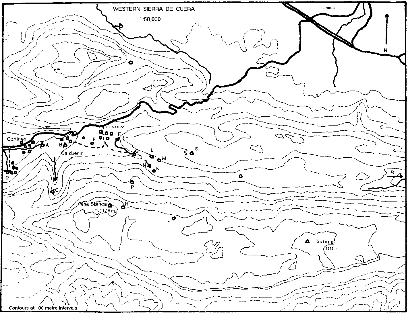
During July and August 1971, Oxford University Cave Club undertook the third in a series of expeditions to the area of El Mazuco in Asturias. Accounts of the Club's previous work in this area have been published in Proceedings OUCC 5 and the Transactions of the Cave Research Group of Great Britain Vol. 13. No. 1.
The major objective of the 1971 expedition was to complete the exploration and surveying of a number of caves which, either for technical reasons or because of pressure of time, the 1970 expedition had been unable to explore thoroughly. The highest priority was given to La Boriza, since it possesses the greatest potential of all the caves in the area. It was for this cave above all that diving equipment was taken to Spain. The expedition also entertained hopes that the summit ridge of the Sierra de Cuera could be persuaded to yield up a pothole which would give a through trip to the resurgence of La Boriza. It was further intended to explore more thoroughly two caves at either extremity of the chosen area, Cueva Laneveru and Cueva de Puron. Neither of these had been fully explored in 1970. Finally, it was the expedition's intention to make a serious search of the whole locality for other caves, something which the previous expeditions had not done since they had had more than enough in the way of caves in the immediate vicinity of El Mazuco.
Followers of OUCC expeditions may be gratified to learn that, happily, the club was rather more successful in extending and finding caves in 1971 than in producing a report on its activities. We feel however that the report contains enough of interest to make up for the inordinate amount of time which has elapsed since the expedition took place.
| Francis Sanders | Dept. Soil Science | Leader |
| Simon Willbourn | Exeter | Secretary |
| Jim Sheppard | Magdalen | Cave Leader |
| Neil Boulton | Queen's | Cave Leader |
| Guy Cox | Dept. Botany | Photographer |
| Andy Brooks | ||
| Mike Allen | Exeter | |
| Dave Brooks | ||
| Antony Comfort | Oriel | |
| Jon Davies | ||
| John Forder | ||
| Dave Peace | Brasenose | |
| Ian Rogers | Hertford | |
| Peter Urben | St. Catherine's | |
| Christiane Sanders |
Pre-departure organisation went very smoothly, apart from a last minute hitch over vehicle insurance. Three Land Rovers and a trailer left Southampton on July 21th, with high hopes of a pleasant journey through France and Spain in these traditionally reliable vehicles. The trailer broke down irrevocably within 50 kilometres of Le Havre. One land Rover suffered a fractured fuel pipe, inoperable clutch, and seized generator. later, in separate incidents, the other two came to blows with a rock in El Mazuco; one of them also hit a milk lorry on the road to Puron.
The budgeted 'contingency allowance' stood up well though heavy demands were inflicted upon it. But an extra 3 a head was needed to finance the acquisition of a replacement trailer, an extremely sturdy ex. U.S. Army design, found in La Rochelle which cost an exorbitant 60 (after considerable haggling). The trailer mishap led, directly to the doubling of the outward leg for one vehicle, as a result of which the whole party was not assembled in El Mazuco until July 9th.
Once established, the pattern of work was soon settled. Generally, there were two caving parties and a beach contingent each day. Later there were more trips further afield, to Purón or La Borbolla, usually leaving a group of surveyors to deal with the extensions to La Boriza.
The campsite was in the same field which had been used by the 1970 expedition, which seemed to have suffered no lasting ill effects, and still sported the same set of tenacious moles. The village headman was again loath to accept the ridiculously low 1500 pesetas that he regarded as the hire charge. Cooking was the main activity, though the primuses were often reluctant. Sorties to bars in Barro, Posada, Cortines and LLanes were not infrequent. Many enjoyable evenings were spent in the bar at El Mazuco, where the villagers were as kind and informative as before. Charging facilities were arranged at the bar at Cortines, mains electricity having reached the top of the valley only in the form of unconnected pylons.
Although we had to pay a tense visit to Oviedo and to the local Guardia, in order to remove suspición arising out of some unspecified misdemeanour by an English expedition the previous year, we did receive a number of more pleasant visits. A group from RAF Lyneham were shown the delights of the Pozo de Fresno and Collau Roviera. Dick Hazelwood, a member of previous expeditions, appeared with some friends from Surrey University; he almost left with one less - he who lost the sump line in La Boriza and was dragged to the surface an amazingly long time later,on the same side from which he had set out. Geoff Mathews of Nottingham University C.C. paid us a visit; so also did the Spanish Girl Guides.
One Land Rover,carrying those with jobs to go back to, left on July 22nd and reached England without incident. The rest of us followed on August 2nd and arrived back in Oxford on the 11th, without airy untoward incident. The expedition finances staggered overdrawn into the Michaelmas term, but soon sorted themselves out.
In spite of the traumatic outer journey, the general opinion was that the expedition had been worthwhile, though not as spectacularly successful in its results as predeparture discussion had anticipated. It certainly produced a considerable amount of information about the caves of this particular area. It also produced one of the most expensive club trailers in the country, and the definite information that there is no accessible system behind Caldueñin.
The expedition gratefully acknowledges the assistance of the Oxford University Clubs Committee, The A.C. Irvine Fund, and those firms who contributed to the stores of the Oxford University Exploration Club.
| A | Nacimiento de Cortines | Survey |
| B | Cueva de Caldueñin | Survey |
| C | Cueva de Laneveru | Survey |
| D | Cueva de Buda | |
| E | Pozo de Fresno | Survey: Survey |
| F | Cueva de Bolugo | Survey: Survey |
| G | Cueva la Boriza | Survey |
| H | Torca La Manga | Survey |
| J | Torca los Corniceros | |
| K | Torcona del Valle | |
| L | Cueva a Sul | Survey: Survey |
| M | Cueva de Callau Roviera | Survey |
| N | Ojo del Rio Bolugas | |
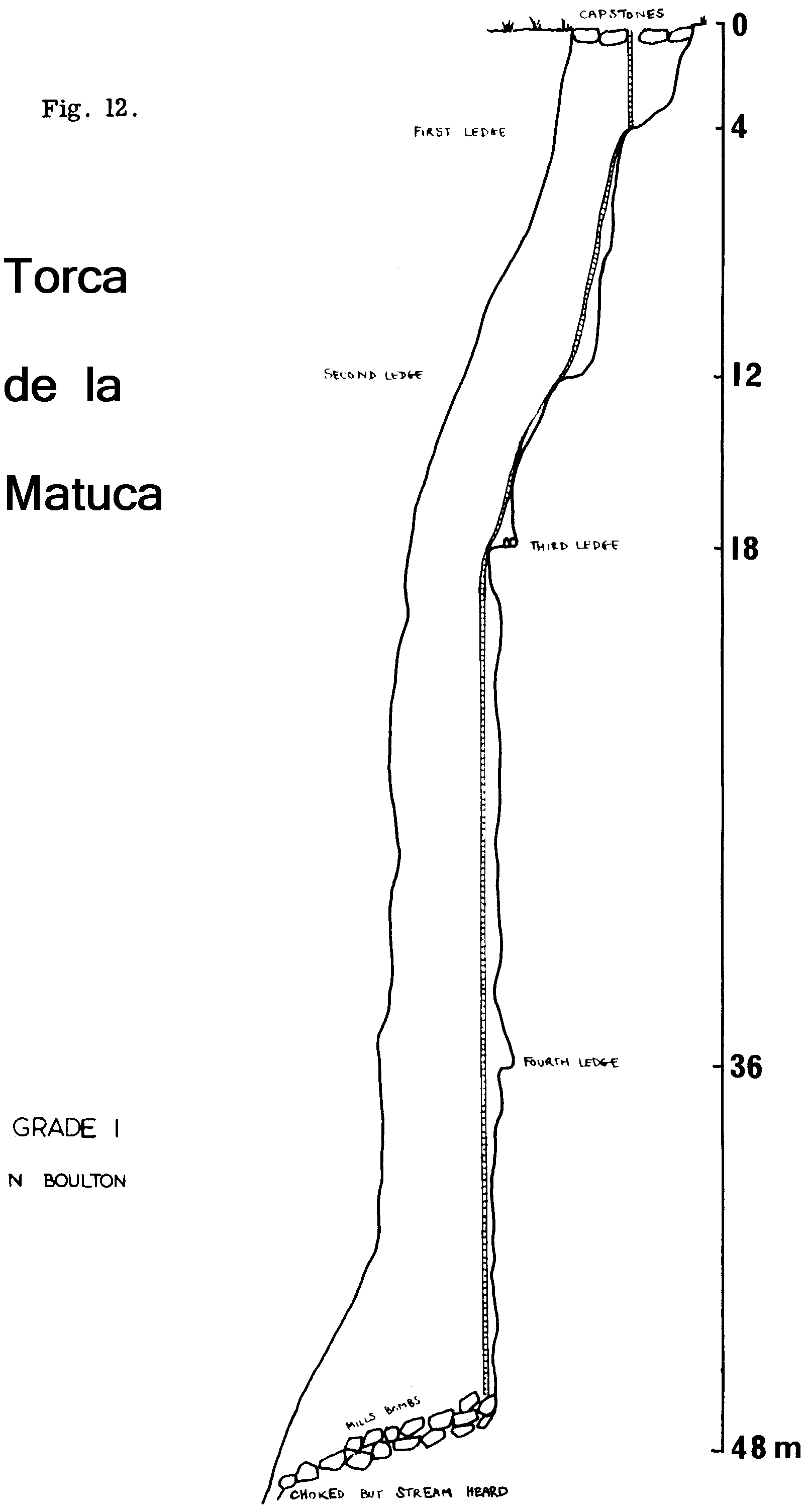
| P | Torca de Matuca | Survey |
| R | El Cuevón de la Pruneda / Cueva de Purón | Survey |
| S | Cueva de Castro | |
| T | Cueva de la Yosa |
This resurgence cave was the major objective of the expedition; exploration in 1970 resulted in considerable extensions to this particular cave, one of the principal features of the hydrological system of the El Mazuco area. About 1 kilometre beyond the first sump, a second sump had prevented further progress along the main streamway. Accordingly, this year we took out diving gear in order to try to extend the cave. From the survey, it has a potential depth of 700 metres. The diver investigated the sump soon after arrival, and reported a series of phreatic origin, leading to a third sump. One session was devoted to an attempt to discover a sump bypass in Shelob's Lair. Access was gained, via the maypole, to a hopeful looking hole in the left hand wall, but it did not go anywhere useful. Attempts to extend the cave from the upstream end were therefore abandoned. Several passages, which had been noticed the previous year, were also investigated, two with a considerable measure of success. One was an abandoned high level series of massive proportions, the other a very fine inlet series, which was extended to a length of approximately 700 metres with the help of the maypole. Surveying this extension proved to be a long and hazardous business, since the passage was extremely tight. A deterioration in the weather towards the end of the expedition did not help. As a result, nearly a third of the expeditions effort had to be devoted to Boriza.
During one of the trips made into the cave in 1960, a large phreatic passage, situated just beyond the last lake, was investigated by John Forder. The tunnel, some 5 metres wide and 3-4 metres high, slopes upwards at about 300 for about 25 metres, at which point it swings left to regain the main streamway at a high level. Just at this point a small stream was noticed, emerging from a low passage on the right and disappearing immediately under the wall. After a short hands and knees crawl upstream the passage assumed more comfortable dimensions and was followed for about 15 metres to a 3.5 metre pitch. At this point the lone explorer turned back.
Further investigation had to be left to the 1972. expedition. The first party found the pitch to be an easy free climb, but a second pitch of similar size, encountered almost immediately, had to be treated with more deference. At the top of this pitch, a small circular chamber, S 6 metres in diameter, was entered; the water fell down a pitch of some 8 metres on the far side. The stal. covered walls offered no opportunity for free climbing this obstacle. However, since the maypole had already been brought into the cave to investigate the walls of Shelob's Lair, and the chamber gave room for manoeuvre, this pitch was soon laddered.
Access was gained to a fine section of stream passage, with several deep pools, cascades, and some decorations. After some 120 metres, another pitch, somewhat larger than the first ladder pitch of the inlet, prevented any further progress on that trip.
A week later the maypole was brought up the section of streamway to the pitch. This passage is indeed fine for anyone not unduly encumbered by ironmongery, but on this occasion some of the free climbs turned cut to be rather arduous and very noisy. When assembled the pole was about 2 metres short of the top; this last section was therefore climbed by pegging into some dubious rock, a process which took about 15 minutes and resulted in everyone becoming not a little damp. Fortunately we were able to warm up once above the pitch, and a trace to the end was won by Neil, over some 550 metres of stream passage. The 'end' is in fact an aven, estimated to be 25 metres high. The stream descends from a point in the roof, which could not be located precisely because of the spray. It would be very difficult to scale this aven; the walls enjoy the protection of the soapy surface of eroded stalagmite, which is a characteristic of caves in this region.
The inlet series more than doubled the length of Boriza. It is essentially a narrow meandering rift passage, enlivened by deep pools, lengthy cascades, and climbs which have to be treated with some circumspection. It was surveyed to Grade 4b, demanding several trips of long duration. The directions of the main and inlet passages are shown superimposed on a topographical nap of the immediate area; a projected elevation illustrates the relationship between Boriza and the various potholes on the mountain.
There is little hope of finding a way to the top of the aven, since it takes only about half the water which appears at the entrance to the inlet series. Several impenetrable feeders have been observed in the series during wet weather. The volume of water in the ml et is approximately a quarter of the main stream.
No tackle was left on the inlet pitches, so it would require more than a tourist trip to revisit the aven in order to test under extreme conditions the newest artificial climbing techniques.
This passage leaves the main streamway a short distance above the third pitch, and is most obvious to anyone going upstream towards Shelob's Lair. Again, it was John Forder who first investigated this inlet, during the 1970 expedition, as part of the frantic search for a sump bypass. The second inlet was not fully explored this year, although a certain amount of time was put in climbing up and down over sump pools. It is essentially a tall rift passage, narrowing down after the relatively spacious section at its entrance, and later widening into a series of small chambers. Whilst a fairly definite end point was reached at high level, some of the less appetising low level routes were not pushed with any show of force. There was never very much hope that the second inlet would provide a bypass, particularly after Andy Brooks had described the second sump. Then it was found that the Inlet Series was going there was even less incentive to look at yet more sumps. Indeed, the Inlet Series attracted so much attention that this particular passage was left unsurveyed.
Halfway up the slope leading to the Inlet Series, an oxbow leads round to the streamway, emerging at an impressive height above the stream in the side of the canyon passage. From the junction, an exposed but easy traverse, first negotiated by Simon, leads through a short grovel in little tubes, to emerge from a hole in the floor of an impressively large passage. This passage is some 12 metres wide and the roof is at least 15 metres overhead. The floor, as such, hardly exists it slopes down steeply to various holes and rifts, through many of which the stream can be heard. Progress is made by walking along ledges and rock bridges, or by climbing over huge fallen blocks. The phreatic nature of the passage is clearly shown by great roof pendants, the rock bridges, and the flakes and projections from the walls. All is now covered with a layer of dry sand.
Back over from the hole, that is, in the downstream direction, a climb up over a rocky slope leads to a tall chamber enterable at a number of levels This contains several unusual stalagmite formations. The main series lies in the upstream direction. After some 60 metres along ledges and slopes at various levels, a climb up leads to a short - and relative - constriction. Beyond this, the 'bottomless' passage continues, but artificial aids would be needed to reach it.
The high level series ends, or seems to end, in a steep slope. Climbing this revealed no obvious way on, though there might be a small passage, difficult to reach, on the extreme right. Neil and John managed with difficulty to climb down to the stream through the rift on the left leading on from the slope. They arrived at a point not far short of Pitch 3 in the main stream.
The discovery of this high level series, together with another large passage leading off at high level from Shelob's lair to just above Pitch 3, found by John, throws new light on the geomorphology of the cave. A more or less complete dead phreatic streamway is now known to exist, parallelling the present vadose streamway. Shelob's lair and the Sump 2 complex above it represent the highest part of this system, still in a semi phreatic state. Below this, a high level passage, long dead, runs from Shelob's lair to the 'Grand Junction'. The lakes which are much more extensive underwater than above represent part of the series, and the large dry passage (shown dotted on the survey) to the east of the present passage is a further part. Celtas Corner and the Sump 1 complex are the final parts of the system met in the present cave. The old system probably flowed out through the now choked passage leading northwest from Celtas Corner, to the old dry entrance in the cliff above the present entrance.
The present vadose streamway contains large quantities of the eroded stalagmite so characteristic of the caves of this region. This could only have been deposited in the last interglacial period. Then the cave would have been much drier than at present. This implies that the streamway existed in the same form as now at least in the Eemian interglacial, and that the vadose streamway therefore probably formed during the kiss glacial period and earlier. The much older phreatic system, which would have formed much more slowly, must date at least from the early Pleistocene. It could date in part from the Pliocene, when the area enjoyed a long period of stability, resulting in a partial planation; the remains of this now form a terrace at 200 metres above sea level (1). Sanders relates the old Boriza entrance to a valley level which he correlates with this erosion level (2).
(1) E. Hernandez Pacheco & F. Hernandez Pacheco 1949 Observaciones respecto a
estratigrafia y tectonica de la Cordillera Cantabro. Bol. R. Soc. Esp. Hist.
Nat. XXXV, pp. 487-499.
(2) F.E. Sanders 1971
Karst Drainage at the Western End of the Sierra de Cuera. Trans. CRG. (Great
Britain), 13. No. 1 pp. 6-10.
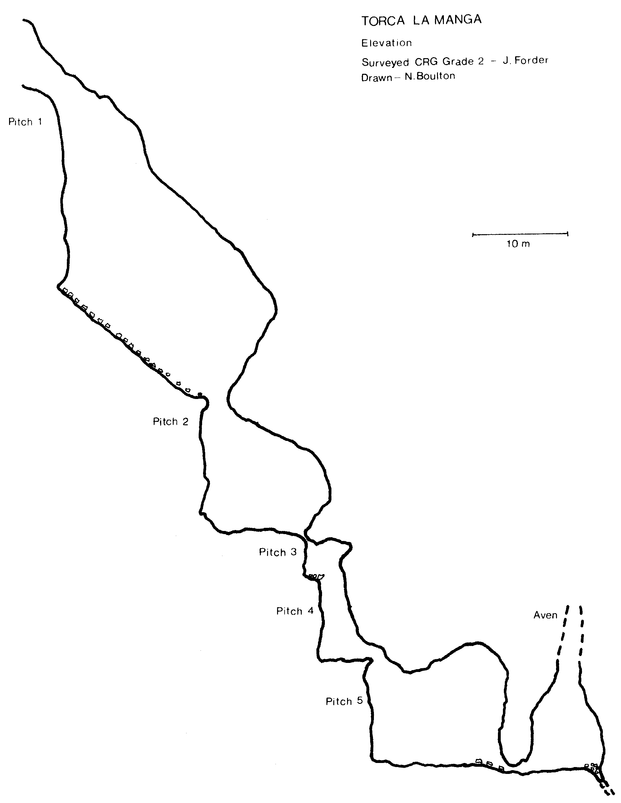
On the summit ridge of the Sierra de Cuera are many open shafts, some of them of considerable depth, though most are choked at the bottom. The expedition entertained some hopes of establishing a connection between one of them and the Cueva La Boriza, which seems to take percolation water from a considerable area. Since the 1970 expedition had enough work in the low level caves, not much attention was paid to the shafts at the top of the mountain. However, one cave entrance, The Torca La Manga had been examined.
Situated in a depression near the summit of Peña Blanca, the entrance is an archway, some 5 - 6 metres wide and 4. metres high, emitting a cool draught. Just inside this arch, the floor fell away in a pitch of 20 metres, which had been descended to a steeply sloping pile of scree. At the bottom of this, after 30 metres, another pitch of 14 metres had been met. Since a minimal amount of tackle had been taken up the mountain, this was the limit of exploration. Because the hole was draughting strongly and did not choke off immediately, Torca La Manga was a high priority for the 1971 expedition.
The first party managed to descend the second pitch and reached a narrow opening which emitted a draught strong enough to extinguish the flame of a carbide light. A large tackle dump was established at the mouth of the hole, and it was with high hopes that the second descent was made.
The first pitch leads to a large, steeply sloping rift, 20 metres high and 1 -2 metres wide, with no solid bedrock discernible until the head of the second pitch - 14 metres - where the slope flattens out into a small chamber. This pitch is situated at the end of another rift, perhaps a continuation of the first at a lower level. After a few metres of straight, high passage, a similar rift was met at right angles to the passage. To the left the passage chokes off after a few metres, whilst to the right it narrows down to a small hole, not especially tight but very awkward because of the number of sharp projections. Just beyond, the passage opened out a little to reveal a third pitch of 3 metres, a long narrow slit in the floor of a small chamber. Again the constricted nature of the pitch, combined with the sharply eroded rock, made the descent tricky. At the bottom the passage widened out once more and a fourth pitch followed almost immediately. This dropped 7 metres through boulders jammed in the floor, and the passage below widened to 3 metres. Yet another short pitch of 10 metres was encountered after a short distance, leading to a circular chamber, approximately 12 metres in diameter and 13 metres high.
On the far side of this chamber was a low, wide arch, which looked like the start of a horizontal passage. It proved to be the entrance to another, somewhat larger, chamber, perhaps 17 metres in diameter with the roof arching overhead to a similar height. Hurrying across this chamber, the explorers found that it was completely choked at floor level by scree which had evidently fallen from an aven of uncertain, though considerable, height. The walls of the chamber were examined by spot beam, but no way on could be seen. The draught which had promised so much could only be felt as gentle waves of air, which presumably filter through the rubble covering the floor.
We had hoped to realise a potential of 720 metres. We had to be content with a mere 80 metres.
In the course of their perambulations on the summit of the Sierra, Francis Sanders and Peter Urben came across a shepherd who promised hem a pothole with a surface shaft of 'mas de cien metros'. Despite their skepticism, they followed their guide to the edge of a large, tree lined, and sloping shake hole. Unable to get to the edge to verity the reported depth, they resorted to the time honoured method of depth divining which is a possible explanation for the high proportion of blocked shafts in this area. Their skepticism slowly evaporated as rocks went crashing down for several seconds.
Two days later, a party returned to the hole with a mountain of tackle. Believing the original estimate of 75 metres with ledges, 80 metres of ladder were lowered and the unfortunate writer secured himself firmly to the lifeline. It soon became apparent that the depth had been underestimated, though it was only it a depth of 4.0 metres that this was confirmed. More ladder was attached and the author descended once more, to discover that he could only get to within 10 metres of the bottom. Fortunately, a stray ladder was discovered, but by this stage it was thought that a fresh climber was needed. Simon got his chance. He managed to get off the ladder at -109 metres, closely followed by Neil, and John who was not to be cheated.
After the first 10 metres, in which one has to negotiate trees and bushes whilst on the ladder, the shaft provided a magnificent free-hanging pitch for the rest of the descent. The walls were shiny, black and smooth. The ledges were non-existent; presumably the depth diviners had ricocheted off the walls. A waterfall, emerging from one side of the elliptical shaft (@ 20 metres by 10) about 25 metres from the bottom, added to the spectacle, happily without affecting the climb.
The water sank immediately into the scree which totally blocked the way down. However, two metres above the floor at its lowest point, there was a tube which was extremely narrow but producing a draught. The smallest member of the trio was inserted into this tube - and stuck after a short distance. Retreating to remove a pullover, helmet and light, he tried again, feet first, only to find that a few metres on the passage narrowed to boot width. In view of the fact that a stream could be heard running below, this was a particularly frustrating end to a very spectacular pitch.
In theory, this hole still has potential. The stream, in dry weather, was certainly in the order of 1 cfps, and if it does not go downstream, could be worth maypoling or pegging up to, in order to look at the hole from which the water issues. One does have the unpleasant vision of climbing the mountain with a ton of gear, only to have a repeat performance on a lesser scale of the assault on a certain pothole in the Middle Fast.
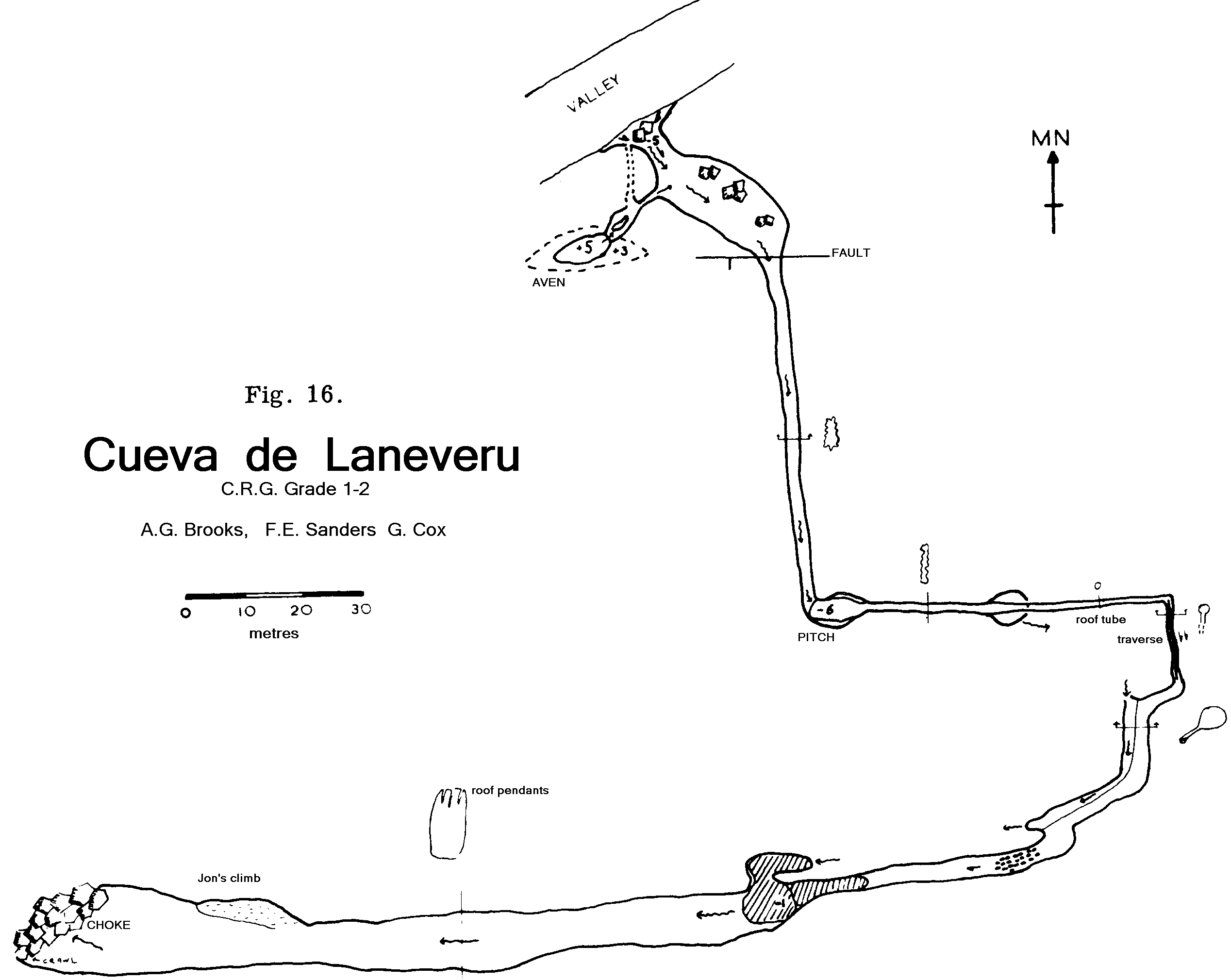
This cave had been brought to the attention of the 1970 expedition when it was the subject of the justly famous 'two Spaniards, two hung-over cavers and a dog' escapade. Initial reconnaissance held out great potential, namely the '2 kilometres to resurgence opinion' which is customarily voiced on such occasions. In the event Laneveru proved to be the ultimate disappointment for the 1971 expedition, and for three of its members almost their final caving trip.
The entrance to Laneveru is situated at the head of a valley of ravine proportions, lying due south of the main Mazuco - Cortines valley. A series of tortuous tracks, obviously pioneered by a breed of threelegged sheep now extinct, gives access to this entrance, a medium sized hole in the base of a cliff. An extremely powerful draught blasts forth, guaranteed to stimulate all serious cavers.
Apart from the first exploration referred to above, one other trip was made to the cave in l970. A climb down from the entrance led to a series of wide and twisting passages, the way on being more or less readily apparent. The passage continued in a horizontal direction, apart from one high level detour, for several hundred metres. The rock was old, of a uniform monochrome shade, and sharp; but the dimensions of the passage were such as to allow swift progress in all but a few places. After some 4.00 metres the character of the cave altered to that of a wide rift passage, with a mud floor and pools, the first indication of water. At this point the first push met with a serious obstacle. This was described as a large and unstable boulder choke, through which there was no obvious route. After attempts to bypass the choke had proved fruitless, Laneveru was abandoned in favour of the more promising caves then at the disposal of the 1970 expedition.
Nevertheless, we had decided in 1971 that, in view of the caves high potential, it ought to be a priority. That it was more or less dry, according to conventional wisdom, was a further incentive. Accordingly, during a lull in the surveying of Boriza inlet, a large party was assembled for an assault on the choke. Far from proving impossible, the choke was pushed without undue difficulty, by the well proven method of crawling beneath the boulders.
The aven beyond the choke was somewhat complicated. The way on led to a chamber which presented the confusing spectacle of humps of rubble, stal slopes, and apparently static pools. An hour's search for possible routes revealed nothing, though in the light of subsequent developments, there perhaps is something. The return journey to the choke however turned up a passage under a rock arch which contained a slow moving stream. This led to a ledge above a large static pool and an extremely evil looking sump - the result of water backing up against a calcite barrier. The sump presented several technical difficulties: unlike others in the area it was not particularly clear, as a result of heavy mud deposits; neither was it of any real depth. In all it measured some 8 metres, but there were a number of useful air bells. The following day a line was taken through and a passage was forced, though not without incident.
The image of railway tunnels beyond, the sump, leading directly to resurgence in the Mere valley, proved to be a mirage. The passage continued through two small chambers and then developed into a high and narrow rift. Furthermore, numerous projections, of unparalleled viciousness, seriously impeded progress. A way on of sorts was forced by the method of clambering up and down rifts in order to follow the widest section. Several members of the party experienced a little trouble in executing this manoeuvre successfully, and a general halt was called. Approximately 100 metres from the sump the rift had become both tighter and sharper; the water in the bottom of the passage had degenerated into a trickle little more than half the width of a boot. Attempts to push on farther proved to be of no avail, and having spent half an hour and half a wetsuit turning round at the furthest point, I can assure any subsequent visitors that only the thinnest of Wharfedale cavers (or Spanish dogs) will get any further.
Despite the initial promise held out by the relatively sizable passage before the sump, there seems to be little chance of success in the totally different conditions which prevail beyond it. No other work was done in the area of Laneveru, because of the steepness of the terrain and the need to devote full attention to the surveying of other caves. Noone could be induced to go and survey Laneveru. But it would be nice to know exactly where the water does go.
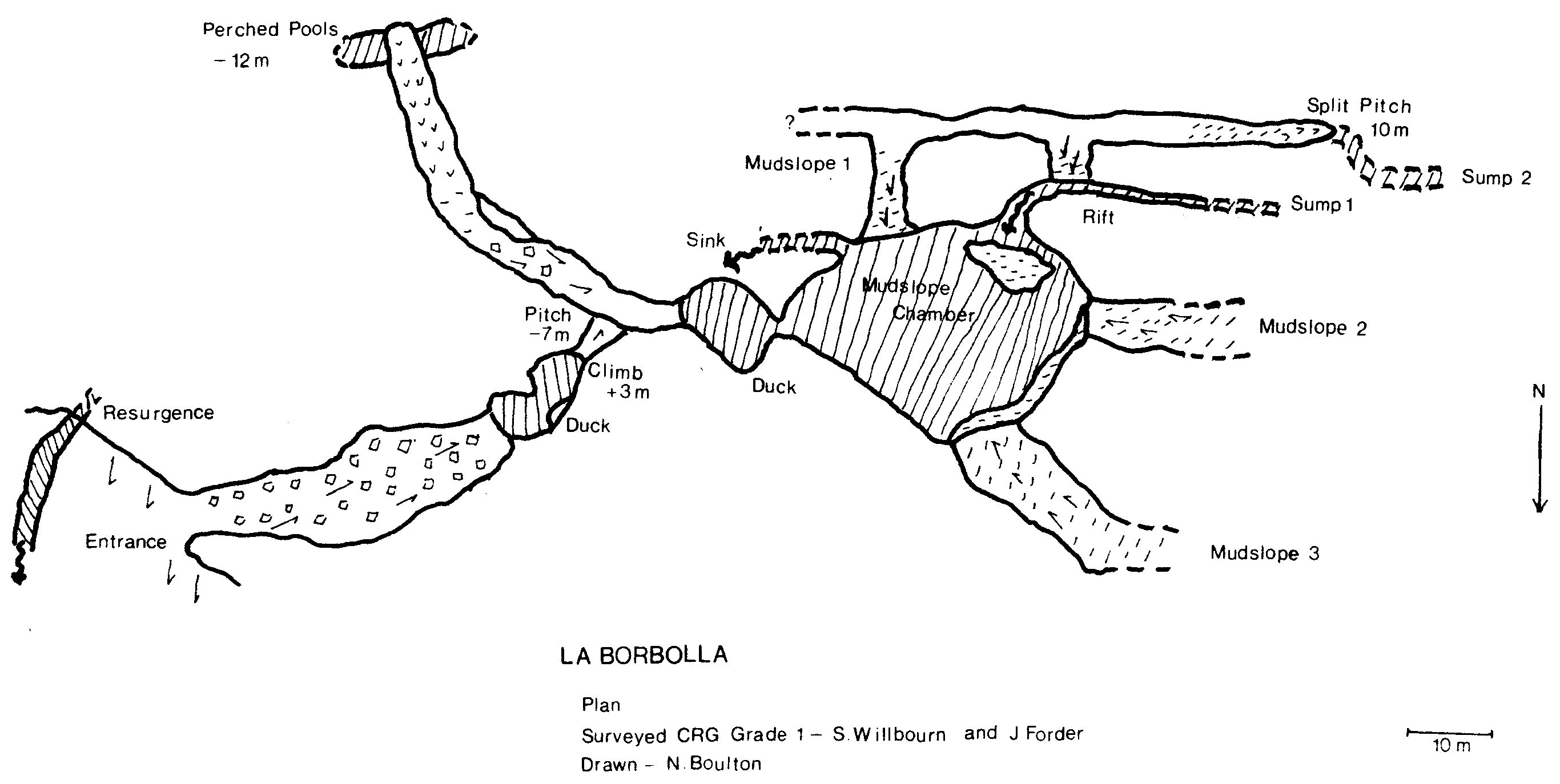
This cave, the source of the Rio de las Cabras, was first encountered by the 1969 expedition during very wet weather, when water was reported to have been issuing forth from all available holes in a cliff face. On our third full day we re-visited the village of La Borbolla, and having dragged ourselves away from the bar, found the cliff after a short walk. The most noticeable feature was a stream emerging from a well defined rift, channelled into a mill race, down the left hand side of the face. The main resurgence was impenetrable from without, but by scrabbling up the hillside through the undergrowth, we reached a spacious archway approximately 4 metres square. This was a dry entrance, although according to reports from 1969 it had led directly to a large lake which gave hopes of a considerable system behind. The floor ran down over boulders and mud to a pool, which was about 4-0 metres in and 6 metres down from the entrance. John Forder plunged off into the unknown, and when he failed to re turn, that was the signal for Neil and myself to change; pausing only to grab a 10 metre ladder, we followed into the pool.
After swimming for only 5 metres or so, we came to an amusing duck, with an even more entertaining eyehole bypass about one metre above water level. This led to a pool enclosed on all sides by rock and stal flow, which entailed a climb Up of about 3 metres. Round the corner was a pitch descending 7 metres, with a very loose take off and which eventually dropped down a rock wall into a dry stream bed. The route to the left led to another perched pool complex after 40 metres of passage. These two pools were investigated on our second trip to at least two metres below surface level, but no exits were discovered. The route to the right led to another pool and the second duck. Beyond this was a sizable chamber, and off to the left the stream disappeared down a rift. It is certainly possible that the Grade 1 survey is grossly misaligned and that the stream at this point is very close to resurgence; the passages are remarkably similar in form. However, I am not convinced that this is the case, since it seemed to me at the time that the volume of water in the resurgence was greater than that flowing through Mudslope Chamber. Fortunately for the law of conservation of matter, we also discovered the entry point of the water into the chamber. Behind the back of a shingle bank, we were able to follow the stream along a deep and sharply sloping rift, about one metre wide and narrowing to 0.5 at the inevitable sump. John and Neil, climbing the rift in an attempt to find a high level bypass, found themselves at the top of Mudslope 1, which I had found to be an interesting climb, and which proved to be an entertaining descent a good 20 metre vertical distance on a 450 slant. The initial party then left the cave, thoroughly confused as to its structure but still with hopes of a way on.
John Forder and I made a second trip a week later and, besides investigating the static pools as described above, explored the warren above the three mud slopes. We descended the split pitch to two deep pools which we labelled Sump 2. We think these are static as well, but did not survey the level with respect to the stream in the chamber. Anyway, we failed to find a way on and, apart from diving the rift sump in Mudslope Chamber, which should in our opinion be tackled by experts, any attempt to get at the master system which lies behind (?) will have to be made from further up the densely vegetated hillside. It is also conceivable that the character of the cave alters drastically every few years when there is heavy flooding, possibly as a result of a severe constriction somewhere in the system. The vertical distribution of water in the section discovered is, to say the least, odd.
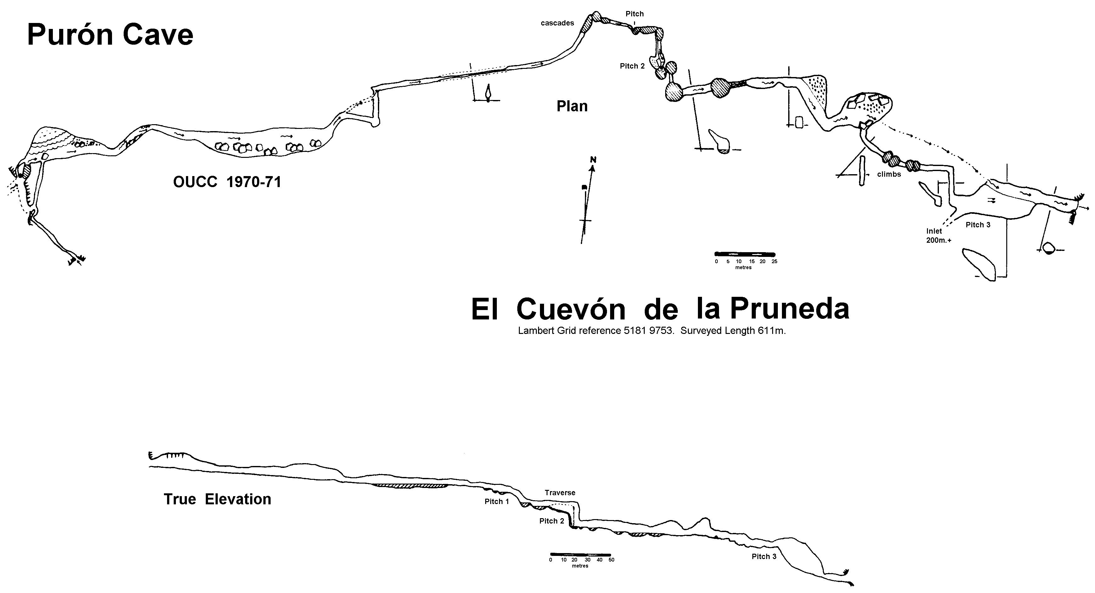
This cave was surveyed to Grade 3a and described to the then limit of exploration in the report of the 1970 expedition. The opinion expressed in that article, that a through trip would be improbable, proved to be unduly pessimistic, despite the logical premise upon which it was based.
The remainder of the cave was penetrated on July 20th, one party having entered by the sink as before, and the second entering by the resurgence; a through trip was made in each direction. The downstream party surveyed back to pitch 2 from the resurgence on their way out. Indeed the 1970 party had been almost within sight of daylight when they halted above the third pitch for want of tackle. The length of newly surveyed passage was 235 metres, giving a total surveyed length of 611 metres for the whole cave.
Briefly, the upper part of the cave begins with two penetrable entrances, normal and flood sinks, which lead to a large and boulder strewn passage. After narrowing at one point, the streamway develops into a series of cascades and pools. The first pitch is made up of two of these cascades, descending at a steep angle. The second pitch drops into another deep pool, the exit from which is a tall, narrow rift. This leads to a larger passage with water up to 1.5 metres deep in one long shelving pool, followed by a series of short cascades. The subsequent stream passage contains water filled potholes from 1 - 2 metres deep in the floor. Two large chambers, the first with a sandy floor, and the second with boulders, carry the stream to a small passage, blocked by substantial boulders. A large flood bypass, with several deep potholes, gives access to the third pitch, where the stream reappears. This pitch is in effect a scalloped slope, set at 300 to the vertical; a ladder as a hand.line is all the tackle required. A traverse from the top of pitch 3 leads to an extensive passage, which was not surveyed but which has an estimated length of 200 metres. This contains a number of small chambers at various levels. Because the passage is dry and muddy, the few decorations in this part of the cave are not particularly impressive. The route from the bottom of pitch 3 to the resurgence is wide, but liberally bestrewn with boulders and occasionally low roofed. The stream emerges into a small wooded valley from a cave mouth 5 metres wide and 2.5 high.
Purón provides a very enjoyable through trip, particularly the sections in the streamway. It is in fact possible to make the trip from sink to resurgence without tackle: all the pitches are free climbable, to anyone who interprets that in a liberal fashion.
(WWW Editor's note. Return the 1980s showed this cave to have multiple abandoned resurgence exits. Tackle IS required for 2 pitches!).
Small extensions, which included some fine decorations and rim-stone pools, were made beyond the Cox Duck (ref. Trans CRG. 13(1) pp 18-19). A free climb up to the roof in the new terminal chamber produced no new route on. A maze of sandy chambers and tubes led off from the north of Boulder Chamber, all returning eventually to the Floodway.
This cave lies behind the ridge on the northern side of the valley leading to the Ojo del Rio. large groupings of sardine tins confirmed reports that the cave, which is of archeological interest, had already been visited by Spanish cavers. The most striking feature of this cave was a carefully constructed flight of steps, perhaps of some antiquity, in the entrance chamber. This led up to the head of a 4-0 metre pitch. At the bottom was a large muddy chamber, with a high roof. Several passages meander off from various points in this chamber, all of them fully investigated and going nowhere.
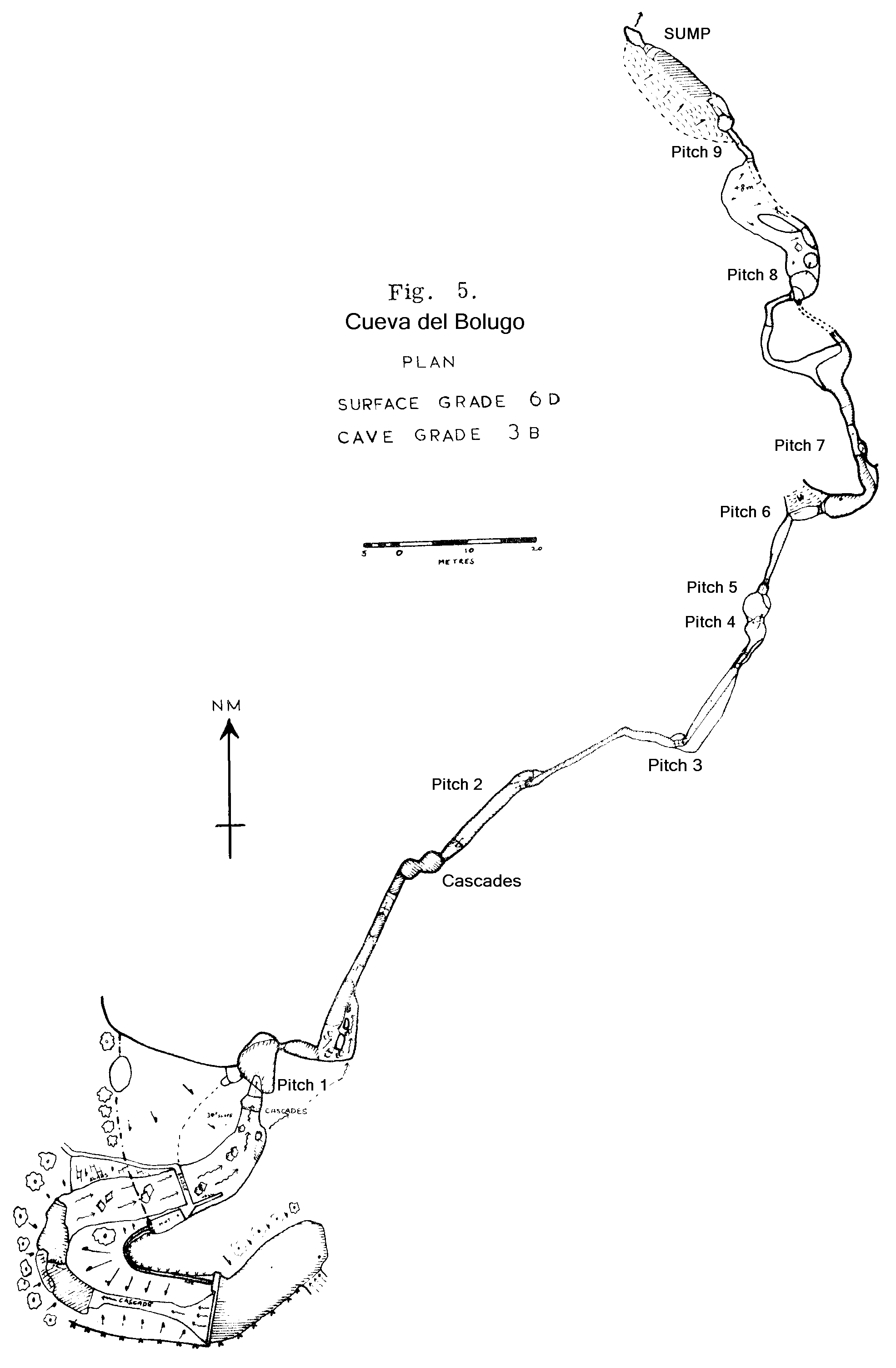
Almost on the last day of the expedition, the village lads took us on a guided tour of the various tiny crevices we had overlooked in the valley. After several miserable holes above Bolugo, in one of which Jon nearly ended his days, the tour led along the steeply sloping hillside beneath the campsite, between Bolugo and Boriza. In a little clump of trees (bosque) was a most unexpected opening in the ground, a miniature ravine about 5 metres deep and 10 - 20 metres long. A little stream ran into boulders, but upstream the cave was open. After a short distance the small streamway became a wet "canal" crawl, but it soon enlarged again. A further low section a tight duck brought exploration to a halt. Without wet suits, and at this stage in the expedition, the urge to push on was notably absent. Besides, the duck looked a bit desperate on carbide
The streamway above the Boriza cliff became the special preserve of Mik Allen, whose objective was to dig his way into the probable phreatic maze beneath the floodway. He had little success, but gained much exercise. One hole did produce about 15 metres of stream passage for a while, but in common with others which were uncovered, had an unfortunate tendency to collapse. Peter Urben took advantage of these new holes 'vadose rather than phreatic' to vary his amusing water tracing experiments.
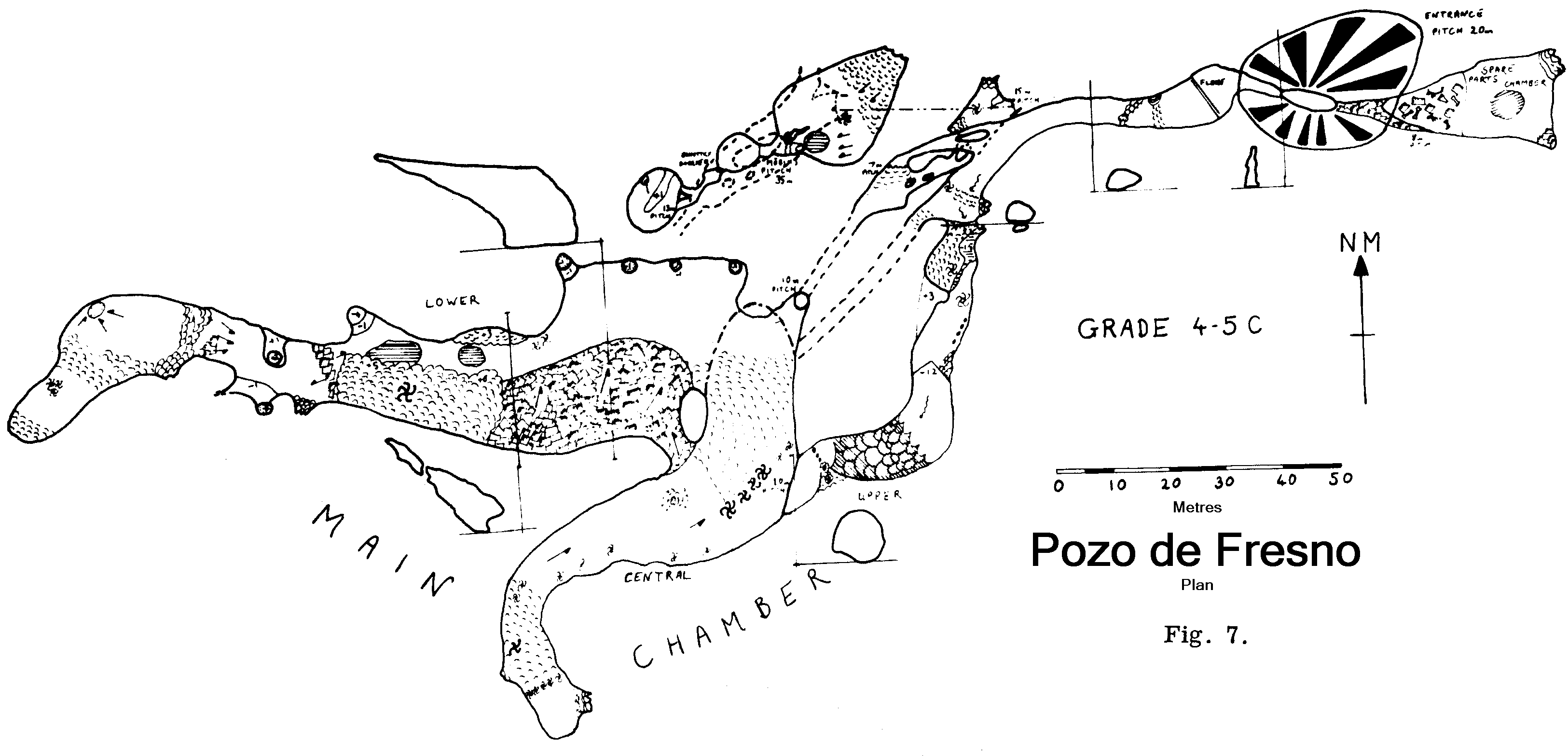
Show cave trips were made into Callau Roviera and the Pozo de Fresno with several villagers and the members of another English expedition. Rotella and its shake holes, and the ridge north of the Cortines road behind the village, were investigated, revealing nothing of any real interest. Barro beach received its fair share of speleologists, who could always justify their presence by investigating the famous 'Barro beach sump'.
The Yosa de Viango is a wide flat sandy doline draining a large area and map 31 shows a stream sinking in it. The 1970 expedition report. indicated that there was an open cave here, but it was not explored. Guy Cox references this report in "Cave Science 51" referring to an abandoned influent cave 100m, Cueva de la Yosa, 100m long, presumably explored by the 1971 expedition. The dry entrance at an altitude of 390m is easy to find amongst the trees in the south west of the Yosa.
As the expedition contained only one trained cave diver, equipment requirements were small. Two high pressure Draeger 43 cu. ft. cylinders and one Sealion 40 cu. ft. were taken, with a Deepstar demand valve and a Snark II as a reserve. 300 ft and 500 ft reels of 0.5 in. circ. Courlene, the usual gauges, accessories and spares completed the kit.
It had been intended to obtain air from a miniature compressor giving 1300 p.s.i. and powered by a 27 V 21A electric motor running from two car batteries. This proved impossible as adequate filters had not been obtained in time. Cylinders were therefore carried out fully charged, in calculated ignorance of ferry and customs regulations, although we were prepared if necessary to blow off the air and have the cylinders charged at Santander.
A communication from the Federación Cantabra de Actividades Subacuationes, Jesus de Monasterio, 20, Santander, mentions charging facilities at Compania Espanola de Oxigeno, Calle Emilio Pino No. 4, Santander; Club 0.1.5., Jardines de Pereda, s/n, Santander; and at Club G.E.A.S. de Aviles. Llaranes, Aviles. All were over 100 kiometres from the expedition's base. I believe that air may also be obtained near Bilbao - the above organisation should be able to confirin this. I can give no guarantee of the purity of the air from any of these sources!
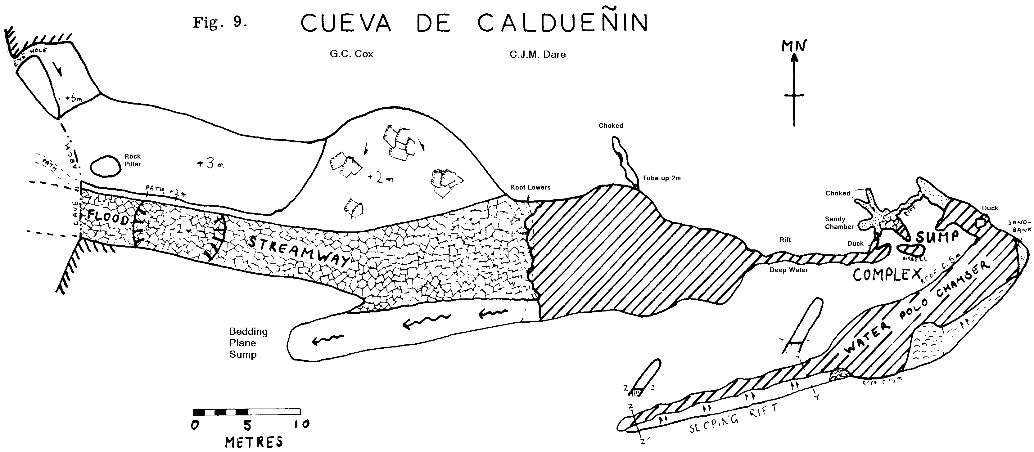
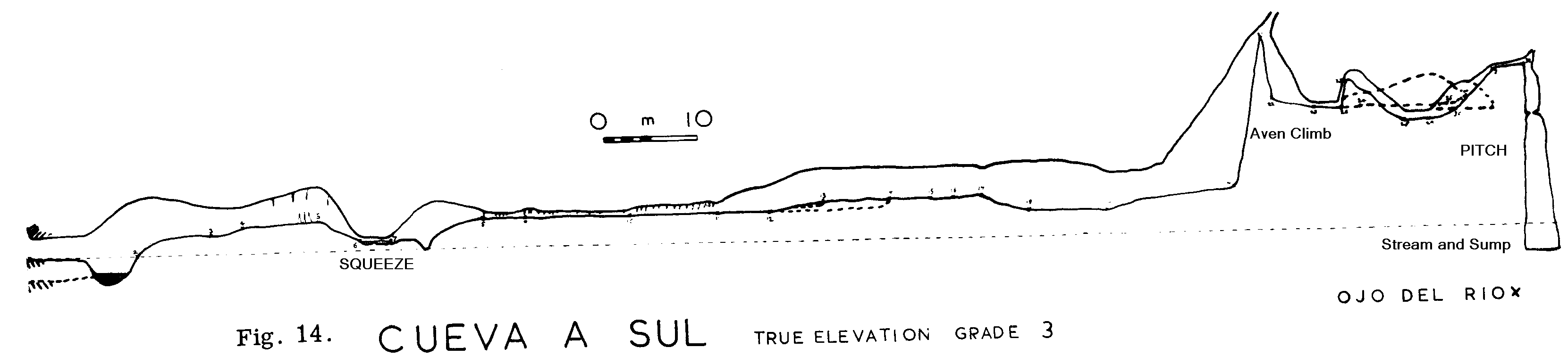
The active nature of most caves in the Sierra de Cuera has been described elsewhere. Progress along stream passages tends to be terminated by sumps rather than other obstructions. There are diving sites in Bolugo, La Boriza, Ojo del Rio Bolugas, Cueva a Sul, Caldueñin, Cortines, Cueva de la Llera, and at Buda and La Borbolla. From the point of view of this expedition, the most interesting sites were La Boriza, Caldueñin, and Ojo del Rio Bolugas. In la Boriza, the steep streamway profile and the abundance of high level routes elsewhere |l the cave had raised hopes of a relatively short sump, perhaps with a by-pass. We had heard that the lake in Caldueñin dried out in drought, giving access to several kilometres of passage. The sump at the Ojo del Rio was known to be short since running water could be heard through a narrow crack only a few yards away.
The upstream sump of La Boriza (sump 2) was dived on July 10th, on a chilling trip when maypoles were also carried as far as Celtas Corner. The dive is straightforward, in superbly clear water and a passage some 3 metres square. A passage running off to the left closes down after 3 metres; this passage was noticed when free diving in 1970 and was then thought to be the main route. The sump is about 17 metres long and a line was left through. There is a convenient platform just beyond the sump, but Boriza 3 consists only of 30 metres of deep canal, leading almost certainly to another sump, though the last few feet of duck were not closely examined.
Caldueñin cave was dived on July 14th, when the downstream sump was visited first. Although this appears to be constricted, the steep gradient of the shingle bank above it and the lack of foam on the water suggests that it is usually little more than a duck. The floor hand side for 20 metres, then crossing to the left and ascending. The two branches of this cave are thought to come from the Cueva a Sul and Torcona del Valle respectively.
Many sumps remain to be dived. However, the most rewarding sites are likely to be those already visited, with the addition of the Cortines sumps. There is scope in the area for both relatively short diving searching for the links between Callau Roviera Survey, Cueva a Sul Survey Survey and the Ojo del Rio - and also for exploring the longer sumps which may exist behind Caldueñin Survey and Cortines. Survey.
A party of two or more divers could explore further upstream in La Boriza or downstream in Caldueñin; both of these may reveal extensive 'dry' passages.
The 1970 Nottingham University expedition, under James Cobbett, has dived a number of sites to the south and west of the Sierra de Cuera. A report appears in C.D.G. Newsletter No. 18 (Jan 1971). Reports on the dives described above appear in C.D.G. Newsletter No. 21 (Oct. 1971).
It all started when the grind of the industrial world drove me to read a volume on care and maintenance of water supplies. Discovering that fluorescein is a bacterial metabolite produced by some common soil and water organisms, and presumably eaten by their neighbours, set me thinking.
For water tracing one needs a detectable additive, of low toxicity, negligible occurrence, and chemical stability. Low cost is equally desirable. One further requirement is that it should not be spectacularly detectable the local populace do not always accept their water supply in a strange colour with equanimity.
These principles brought to mind phosphates, not widely distributed in nature and largely locked up in the higher forms of life. Save where man is active agriculturally and domestically, the background can be expected to be low, but they are easily detected by an extremely sensitive colour test, though invisible to The naked eye. All the other advantages they possess, with the exception of probable absorption into the geological media of caves.
It was found that in South Wales, phosphates were not detectable in cave water, except in Forth yr Ogof. This may be due to agriculture, washing in the Mellte valley, or indeed to the CDG.
Thus a short system was needed to test whether phosphates introduced into a sink, would reappear at the resurgence. Francis and myself bethought ourselves of Spain. The Ojo del Rio sinks shortly after appearing, and was believed to reappear some 300 metres away and 60 metres lower. With a gradient of this size, a through time of less than an hour is to be expected, if, as seemed likely, a vadose system is present.
Comparison with fluorescein is a good idea. After procrastination and delay by a sprained ankle, I put 15 grams of fluorescein and 100 grams of Na3PO4. into the Ojo del Rio streamway one afternoon and charcoal detectors into the resurgence below Boriza, to extend the sensitivity of the fluorescein. A wet two hours later regular testing of the resurgence showed no trace of either additive. The next day the detectors showed no trace of fluorescein.
Another addition of fluorescein was made, 60 grams this time. The detectors remained inaccessible for some days as a result of flooding just after the injection, but when extracted and placed in sodium hydroxide solution, they showed no fluorescein but merely a yellow brown muck.
This raised the question of where on earth the Ojo del Rio was going. Was the Bay of Biscay now bright green? Drastic measures were demanded. 250 grams of fluorescein were put into the sink.
By this time Francis and Mik had dug down to the stream, halfway between sink and resurgence, so that a shorter test route for phosphate was available. I spent two wet hours in the rift carrying the stream, sampling the water and staring at the trout which were hiding from Francis' rod. A connection thus far was proven as the water was green from the fluorescein added five hours earlier and. present at this point in a concentration of rather less than 1 ppm. No phosphate was detected in two hours, and no fluorescein had appeared at the resurgence.
The next morning Mik insisted that the stream above Bolugo was bright green. I was not so easily persuaded and required a third look. It was green - very! The water did not show fluorescein in a litre bottle however, which meant that the concentration was less than 2. x 10-8. A quick tour of bars was needed however, drinking green water to show how healthy it was.
We had at last proved the connection between sink and resurgence, but turning the Bolugo stream green for a full day was not the most politic way to do it.
To cap this, the samples from the detectors after the second injection of fluorescein were found to have thrown out a dirty brown precipitate, and were yellow green. Three morals can be extracted from this tale:-
1. The minimum detectable amount of fluorescein is that which cannot be missed by any peasant within 5 miles.
2. Fluorescein is at least two orders of magnitude more detectable in a stream than in a laboratory.
3. All caves in the Sierra de Cuera are phreatic and extremely wet.
Meanwhile, if anyone knows of a nice short vadose sink and resurgence system, I would like to find out whether phosphates will get through an underground streamway.
A considerable proportion of the expedition's time was devoted to surveying, notably the extensions to La Boriza, which were extremely time consuming. Accurate surveys to CRG Grade 4 were carried out in major caves; other surveys were generally Grades 1-2.
The instruments used were: Suunto compass; Suunto clinometer; fibreglass tape. The underwater survey pad, which had been constructed for the 1970 expedition and had proved indispensable, seemed to have been abstracted in the intervening 12 months. In consequence, we had to use a large number of ordinary note pads; the results survived.