Oxford University Cave ClubProceedings 5 (1970) |
OUCC Home Page |
J.A. Winchester
(Report of the Geological Section, O.U. Expedition to North Spain, 1967)
Stratigraphy and rock types, Structure, Cave morphology , Sedimentary structures within the caves, Mineral veining, Cerredo, Candina, Conclusions, References.
West Cerredo geological map (High; Medium resolution); El Mazuco area map (High; Medium resolution)
The geology of the area around Castro Urdiales was studied in order to assist the expedition to locate new cave systems, and to explain the present form of the caves. A geological map was constructed, based on evidence gained from field work on the surface, then some underground correlation was attempted in one of the largest cave systems.
In this report, different aspects of the geology will be dealt with in turn; notably the different lithologies distinguished on the map, the structure, and the cave relations within the main area map. Shorter notes will describe the sedimentary structures noted inside the caves, and the mineral veins seen in the area, and these will be followed by a brief description of the areas reconnoitered but not mapped in detail.
Castro Urdiales lies on the north flank of the Cantabrian mountains, a range uplifted during the Hercynian movement at the end of the Paleozoic era, along the northern margin of the Spanish Meseta. Over a large part of the Basque provinces the sediments postdate the main orogenesis, being of Mesozoic age, but they bear witness to the later movements in the Tertiary, which re-elevated much of the chain at the same time as the Alpine earth movements.
In the neighbourhood of Castro Urdiales, the sediments now exposed at the surface are all of Cretaceous age, consisting of a lower Cretaceous "Wealden" series of flaggy sands and shales, overlaid conformably by the "Urgonian" series, embracing the Spanish upper Cretaceous, and consisting largely of limestones.
The structure of the area consists of broad open folds, with axes trending approximately from East to West, but these are greatly complicated by faulting. Both folds and faults probably date from the movements in the Tertiary.
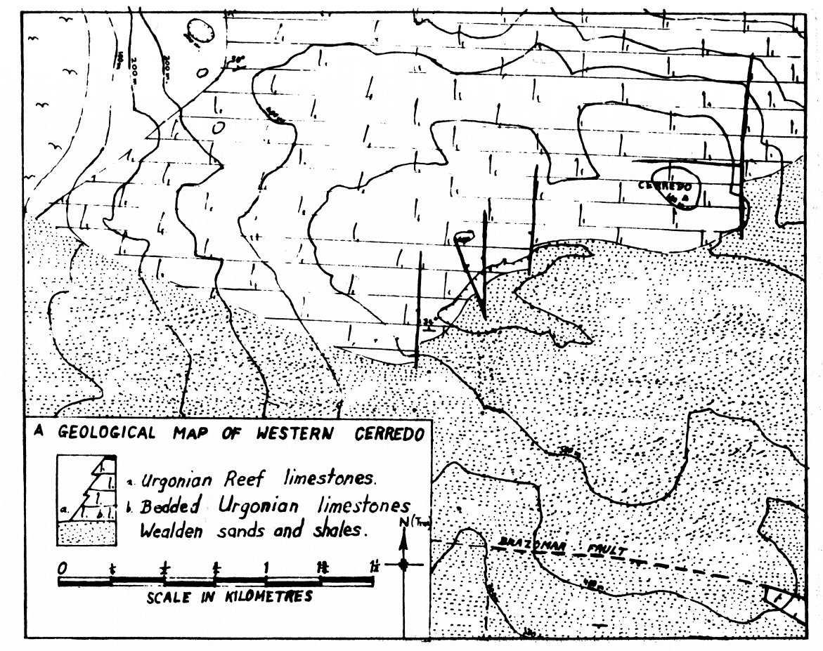
Urgonian limestones outcrop in two main areas west of Castro Urdiales which are separated by an anticline with Wealden exposed at its crest. The more northerly outcrop covers the summit ridge and northern slopes of Cerredo, and extends west beneath the Rio de Oriñon to include the whole of Candina, the Liendo polje, and the hills south of Candina. The southern outcrop is much smaller, structurally almost a graben
between two strike faults, and extends from La Pena in the south-east to the western summit of Punta Peña. All the caves currently explored, with the sole exception of the Cueva de Iseca Nueva near the Liende polje, were situated in the latter limestone area, and therefore the geology of Punta Peña was mapped in the greatest detail. The geology of La Peña, separated from Punta Peña by a broad expanse of valley alluvium, was not mapped in view of its structural simplicity, but the relatively complexity of Punta Peña made a map essential. When this had been completed, a few days were spent reconnoitering the limestone on Cerredo, and an approximate map of the south and west of this mountain was produced.
Since the limestones are the only rocks important to cavers, mapping was only done in and around the limestone areas. Thus the Wealden occupying the crest of the anticline between Punta Peña and Cerredo was mapped very briefly; it was only checked to ensure that no limestone outliers were overlooked, and so that the broad structure could be noted. Many of the dip and strike readings, however, have were taken from the Wealden bordering the limestones, since either weathering, or the frequent total lack of bedding planes in the limestone meant that Wealden readings were generally more accurate than those in the Urgonian, and thus a clearer picture of the local structures could be obtained.
In view of the size of the area mapped, and the short time spent in the area, some features of the local geology will undoubtedly have been overlooked: however, it is hoped that this study will clarify some of the reasons for the siting and the orientations of the cave systems in the area.
Top, Structure, Cave morphology , Sedimentary structures within the caves, Mineral veining, Cerredo, Candina, Conclusions, References.
West Cerredo geological map (High; Medium resolution); El Mazuco area map (High; Medium resolution)
A number of different rock units are distinguished on the map drawn up of the Punta Peña area. Since some of the units vary quite widely, all these are described in order to explain which rock types are included in each unit.
The Wealden is the basal unit of the area, and conformably underlies the other units, as seen near Penilla and on Cerredo. Although a considerable thickness was exposed in the area, it was not subdivided into separate units as it is lithologically monotonous, and of no importance to cavers. It consists of micaceous purple and brown sands alternating with blue shales, almost always non-calcareous, sometimes fossiliferous, and showing many sedimentary structures. Possibly it was a terrigenous shallow-sea deposit.
Near Penilla the Wealden is overlaid by a grey, arenaceous, micaceous limestone, containing abundant fossils: probably Orbitolinids. This unit appears to form a transition group between the Wealden and the limestones above. It was only seen north-west of the mouth of Penilla, where it was about twenty feet thick, and it is probably only a local development; perhaps a shell-bank deposit.
The more widespread unit distinguished at the base of the Urgonian series is a grey, fine-grained argillaceous limestone, containing abundant recrystallised casts of un-broken bivalves, known here as the "bivalve unit". Although similar limestones were occasionally seen in small quantities at other horizons, the bivalve unit was developed North and East of Penilla, where it was up to three hundred feet thick. It also made up the entire Penilla stream outlier, a mile to the West of Penilla.
The "well-bedded limestone" unit embraced all the reasonably pure limestones in the area, which displayed clear bedding planes. It was unrelated to grain size or colour. Grain size varied from extremely fine to course recrystallised limestones, while the colour varied from pale buff to dark grey. Possibly there is some development of cycles in these limestones, as the occasional sharp junction with a coarse grained bed resting on a finer one was noticed. Fining-up sequences may occur locally. Fossils were sometimes abundant, and sometimes almost completely absent. When present they were usually broken, so these well-bedded limestones may normally be classed as bioclastic. They were probably detrital material derived from the nearby reefs, and were laid down in an area greatly disturbed by wave and tidal action; hence the fragmentation of the fossils. Depositional dips may render the dip readings taken somewhat unreliable. These limestones were seen best on the south slope of Montealegre and on the south facing scarp of Cerredo.
A separate unit not on the map is the alternating shaley and flaggy limestones. These consist of a rapid alternation of calcareous shales, shaley grey limestones and some arenaceous limestones. Its boundaries are poorly defined in the field and it was interpreted as a transition unit between the well-bedded bioclastic limestones and the calcareous shales, into both of which it grades both vertically and laterally.
Calcareous shales are distinguished from the alternating unit on the map when the shales are clearly dominant, although thinner limestone may still be present. The main locality where these were noted is near the Sangazo resurgence, and over the ridge to the north-west, but two other localities were seen on of Montealegre, in addition to another on Punta Peña.
The last unit marked is the reef limestone. Typically this is extremely varied, and contains the occasional small lens of bedded limestone too small to be shown on the map. Usually, however, the reef limestones show few signs of bedding, and consist of fragmented fossil remains mixed with others, possibly in situ. The grain sizes vary enormously, and local brecciation was noted, possibly indicating incipient dolomitisation. Joint planes were dominant in this, and usually dictated the cave-forms in the reef limestone.
To understand the stratigraphy, the relations between these rock-types must be known. The Urgonian appeared to overlie the Wealden conformably wherever a sedimentary contact was seen, the basal limestone usually being the grey argillaceous bivalve unit, except where the orbitolinid unit was developed beneath it. The bivalve unit seems unaffected by reef limestones; it probably underlies them, and thus represents a phase before the reefs started to form. Three main reef masses were noted in the Punta Peña Urgonian; a northern one on the north side of Montealegre, and extending East to Monte Pino, and two on Punta Peña, locally connected but also divided by patches of shale and detrital limestone, such as that seen near the ridge of Punta Peña due south of the summit of Montealegre.
The remaining units, the bioclastic limestones, the alternating unit and the calcareous shales, are probably contemporaneous with the reef limestones, as they break into one another and have lithological contacts with the reefs. The bioclastic limestones may be interpreted as the purest reef detritus, while the shales are probably clastic deposits derived from land, possibly the result of river transport. Where the water was muddier the reef development was prevented, and the alternations of shale and bioclastic limestones probably developed in a channel through the reef. Although thick vegetation made accurate appraisal of all these contacts difficult, this was taken as the likeliest interpretation of the stratigraphic column.
Top, Stratigraphy and rock types, Cave morphology , Sedimentary structures within the caves, Mineral veining, Cerredo, Candina, Conclusions, References.
West Cerredo geological map (High; Medium resolution); El Mazuco area map (High; Medium resolution)
The form of the outcrop on the map suggests that the structure of the area west of Castro Urdiales consists of broad open folds with axes trending east-west; the Punta Peña limestones lie in a southern syncline, separated from the Cerredo limestones by an anticline with a Wealden core.
Closer inspection shows that faulting is everywhere a more important important factor than folding: for example, in the Punta Peña syncline the regional dip is always to the south, while the only folds noted were wrinkles affecting the general southerly dip only slightly.
Major folding probably does occur, although the main structure seemed more the result of faulting. Minor wrinkles undoubtedly occur in many places, as both the dip and the strike vary within wide, but quite definite, limits.
All these, however, were of small importance when compared with the importance of faulting. Faults were common in the Punta Peña area: it was bounded by four major faults, while several smaller ones were also seen, especially where the limestone had been brought down against the Wealden. Three of the main faults were strike faults; in fact the Punta Peña area could be interpreted as a graben bounded on the north by the faulting referred to here as the Brazomar fault, and on the south by another parallel fault called here the Punta Peña fault. It was mapped by Rat as extending east to down the south side of la Peña also, and near the summit of Punta Peña it was estimated to have a throw exceeding two thousand feet. The third strike begins north of Penilla, and runs south-west until it meets the Punta Peña fault. It has a down-throw to the south, and is he referred to as the Penilla fault.
Running through the saddle between Montealegre, and the spur of Cerredo to the west is a fourth major fault, here known as the Montealegre fault. It runs almost due south from the Brazomar fault until it ends on Punta Peña, and is not evident in the line of precipices which mark the Punta Peña fault. With a downthrow, to the east, of not less than seven hundred feet west of Montealegre it forms a large step down in the floor of the graben. Minor faults also cut in both directions, forming a number of small fault-blocks. Small scale strike-slip movement may occur, and this is suggested by the offset of the major fault by minor ones.
Faulting is evidently more dominant than folding in controlling the structure, for the throws of the main faults are far larger than would seem justified by the intensity of the folding. Deformation has been more brittle than plastic, and this may imply either that deformation took place at a relatively shallow depth, or that basement control exercised by the Hercynian core of the Cantabrians had no great depth is the main influence, and that re-activation of old fault lines may account for the type of deformation apparent at the surface.
With this in mind, a discussion about the likely nature of the Cerredo anticline may be of interest. Neither of the two readings taken north of the Brazomar fault shows the southerly dip typical of the Punta Peña area, and all the other dips noted, but not measured, north of the fault appeared to be in agreement with the readings taken. One reading showed a dip to the west, but was probably influenced by the fault movement, which was within a hundred feet; the other showed a dip of 30 ° to be north, a figure strikingly similar to those measured later on Cerredo, and all the other dips and strikes noted in the neighbourhood were similar.
Further west, southerly dips were noted in the Penilla stream outlier, while northern dips were noted half a mile north-west of it, near the track up Cerredo. The crest of the anticline apparently lies between the two. If so, it was later seen to be in alignment with the Brazomar fault and it is possible that the fault may continue westwards separating a north-dipping block of territory from one that dips to the south. The position of the German oil - drilling platform may also be significant, indicating the crest of the anticline whether faulted or not. If the Brazomar fault does extend to the west the saddle north of spot height 383 metres may be a topographic expression of its position. The evidence does suggest indirectly that the crest of the anticline is faulted and since elsewhere in the district faults cause radical changes in the dip and strike the Brazomar fault may form the sharp junction between the Cerredo block and that of Punta Peña.
The strikes of the main structures usually run east-west. This
applies both to the major strike faults and to the folds they
accompany. In addition, however, there are smaller faults which
trend north-north-east and north-north-west. These may exhibit
strike-slip movement, such as where the Punta Peña fault
is offset, and may by their stress-pattern support the suggestion
that north-south compression is responsible for the present configuration
of the local structure.
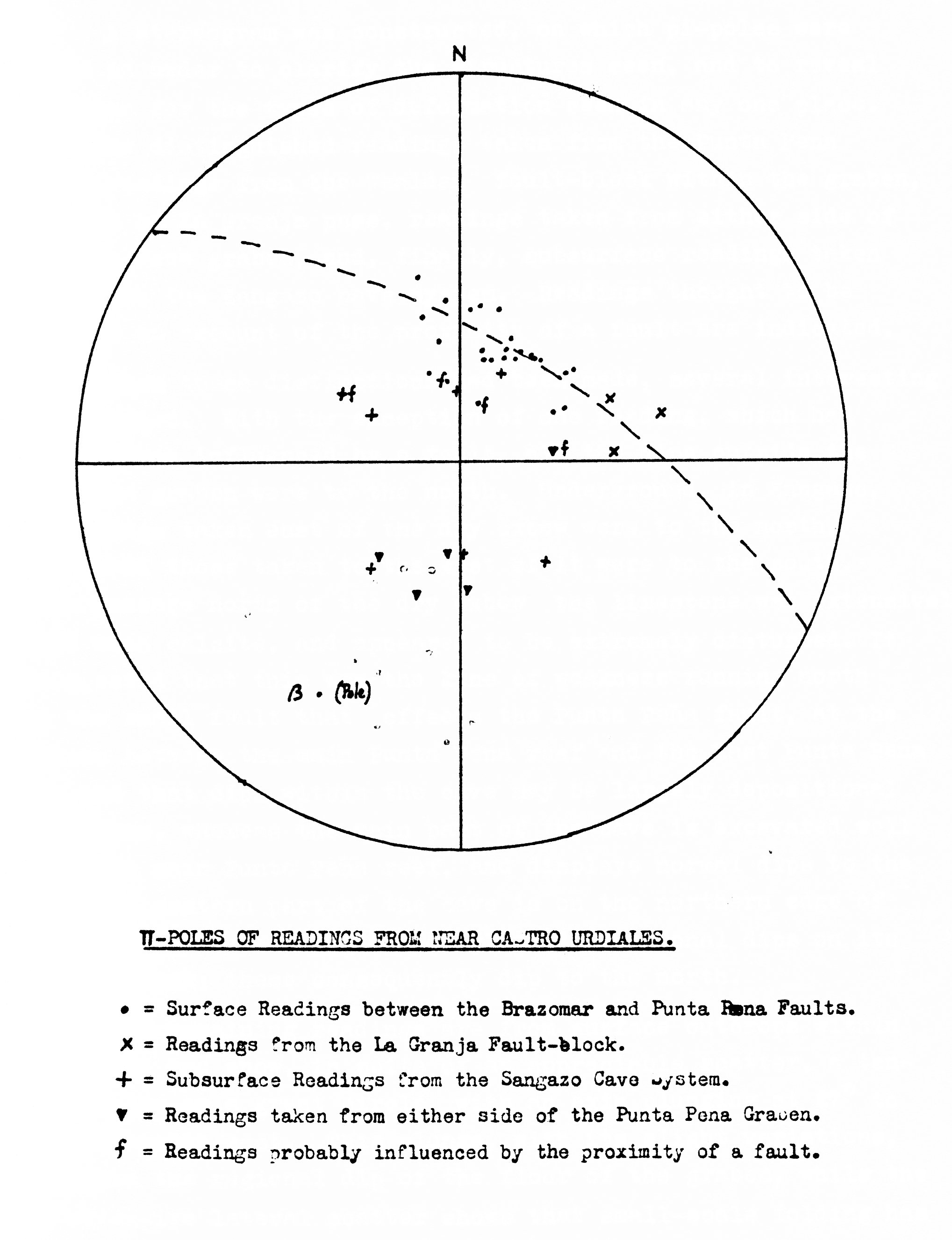
A stereogram was constructed, on which pi-poles were plotted in order to clarify the structures seen, and to reveal any reason for the types of deformation seen in any one place. On it were distinguished readings taken from the Punta Peña graben, readings from the Wealden fault-block within the graben, just east of La Granja pass, readings taken from either side of the Punta Peña graben, and, finally, subsurface readings taken from within the Sangazo cave system. Readings thought to be anomalous on account of the proximity of a fault are indicated.
When these distinctions had been made, several interesting facts emerged. With the exception of one reading, which had probably been influenced by a fault, all the dips outside the Punta Peña graben were to the north. Underground, in Sangazo, all readings taken east of the dry oxbow were to the north, whereas all those taken to the west of it were to the south. In the passage north of the dry oxbow the limestone was extensively veined with calcite, and appeared to be extremely disturbed. It is suggested that this was the line of weakness running north from the small fault that offset the Punta Peña fault, at the junction between the main Punta Peña reef and the east Punta Peña reef, and that dips within the cave may be largely depositional ones. Thus, whereas the main part of the cave is excavated well within the main Punta Peña reef, and displays normal dips to the south, the eastern part of the cave is on the northern edge of the east Punta Peña reef, and displays depositional dips on its northern flank; these consequently dip to the north.
The remaining readings are from surface outcrops within the graben, and show, in spite of an appreciable scatter, a tendency to lie on a great circle, with an axis plunging at 27° to the north-north-east. This plunge, with its slight variations, represents the regional dip of the floor of the graben, while the more expensive lateral scatter shows that small-scale folding has occurred, in addition to the regional dip. If tilting had not occurred, these open folds might have produced dips of up to 15° to the east and west. These are the wrinkles already mentioned.
The conclusions which can be drawn from the stereogram are that faulting is responsible for the major regional dips, but that small-scale folding is also present, being probably independent of the main fold episode.
Top, Stratigraphy and rock types, Structure, Sedimentary structures within the caves, Mineral veining, Cerredo, Candina, Conclusions, References.
West Cerredo geological map (High; Medium resolution); El Mazuco area map (High; Medium resolution)
Cueva de Sangazo survey: High; Medium: Low resolution
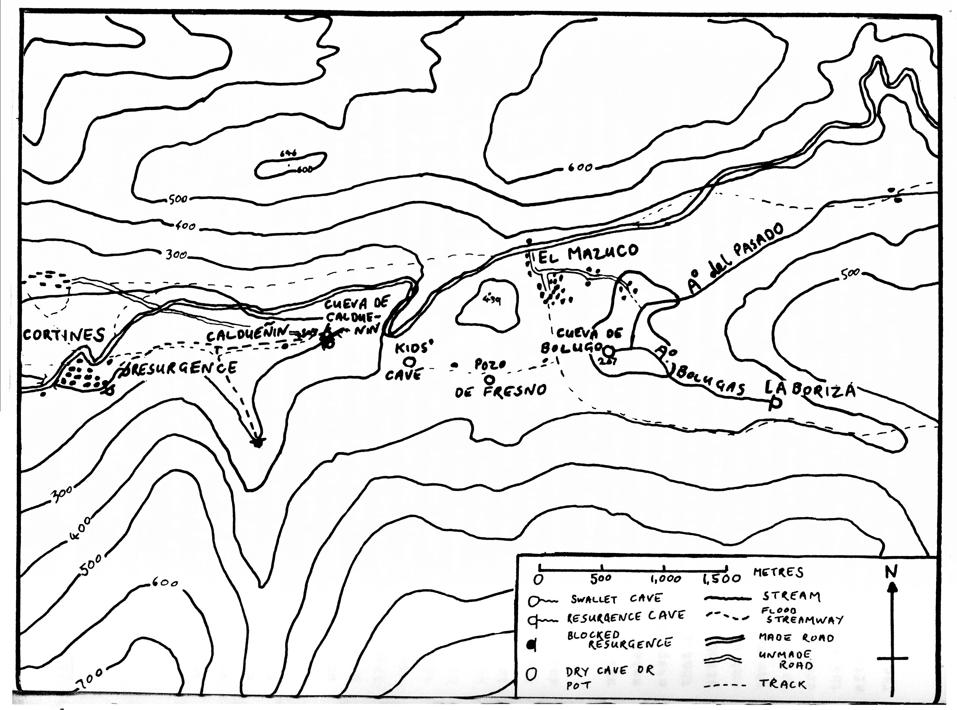
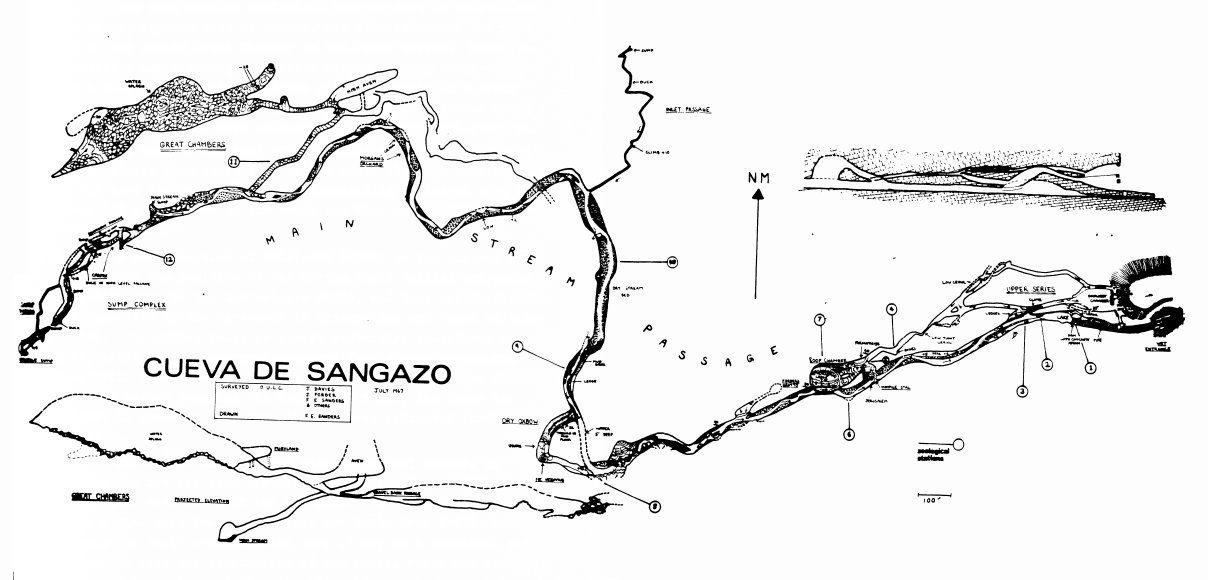
Only the Sangazo system was studied in detail, but all the other caves visited seemed to exhibit similar features. Sangazo was chosen for two reasons: it was the most extensive system in the district, and it directly underlay the area being mapped. Quite apart from providing useful additional exposure it also showed how a cave form was produced by the action of water, and the influence of geology on it. In Sangazo the rock types vary between massive unbedded reef limestone, and the bedded bioclastic limestone which may be local reef detritus. Nevertheless, Sangazo has been excavated mainly in a reef limestone mass, and nearly every other cave of any size in the Punta Peña area, including Penilla, Sinister pot and the cave above Montealegre village, has been eroded out of similar reef masses. Only a few small holes and the Penilla outlier caves form exceptions to this rule.
The influence of jointing and bedding, where present, on the cave forms was noted. Cave formations tended to occur below joint planes down which water could seep, and these planes of weakness in the rock also controlled the form of the cave passage. If the bedding was dominant, the passage tended to be broad but not high, the roof sometimes being formed by a single bedding plane. If jointing was dominant the passage tended to be elongated in the direction of the planes. More commonly it varied between the two extremes, and joint influence was less important than the erosive power of the river.
The most notable geological feature seen in Sangazo was the fault, exposed best at Carfax, but also seen near the west end of the second great chamber in the upper series. Where the relatively small passage at Carfax turned sharply north-south for a short distance its roof was a fault breccia in a crush zone 40 feet wide. On each side were broad disturbed zones where the limestones were extensively veined with calcite. The limestones seen to the west of this fault were quite different in grain size from those seen to the east, although both belonged to the reef limestone series. Slickensliding indicated that the fault had a downthrow to the east, and that movement had been almost vertical.
Superposition of this cave survey on the surface map showed that the position of the Carfax faults tallied extremely well with that of the Montealegre fault, and this correlation was supported by the agreement in orientations and throw of the faults. The Carfax fault is almost certainly, therefore, the Montealegre fault discovered somewhat further south than was positively traced on the surface. Since the Montealegre fault dies out before reaching the Punta Peña fault, the throw in Sangazo is probably less than the 700 feet estimated further north.
The nature of the other main geological feature in Sangazo has not yet been discussed. This is the extensively veined zone seen north of the dry oxbow. It is in line with the small strike-slip fault offsetting the Punta Peña fault, and although no fault occurs in the cave it may be a tensional zone associated with the termination of the fault, which may still show some lateral movement. Significantly it is here that Sangazo has its largest north-south bend in the passage, and since the bend of the passage is in the same direction as the lateral movement once was, the geology may have influenced the course of the river. Surface mapping suggested that this line was the junction between two reef masses, now divided tectonically as well as stratigraphically. Their influence on the dips has already been mentioned, but they southward transport of the East Punta Peña Reef has bought relatively impervious shales into line with the upper cave passage. It is suggested here that the great bend in the cave passage is unrelated to actual moment of the fault, which must have occurred much earlier, but is a result of the diversion of the river to follow the line of the most permeable rocks. The positioning of the rocks is the result of tectonics; the course of the river is the result of the positioning of the rocks.
Top, Stratigraphy and rock types, Structure, Cave morphology , Mineral veining, Cerredo, Candina, Conclusions, References.
West Cerredo geological map (High; Medium resolution); El Mazuco area map (High; Medium resolution)
The river in the cave at Sangazo exhibited many of the characteristics of the streams outside, and shown in particular meanders, sand banks, pebble banks and the alternating succession of pools and chutes typical of fast flowing streams. However a few important differences were noted. The meanders could be seen in three dimensions, the higher levels of the passage having been hollowed by the stream on its previous meanders; the passage therefore displays a criss-cross pattern. Abandoned oxbows also occur, but in these the stream has cut through the neck by burrowing underneath, following a new plane of weakness in the rock. A good example of this can be seen in the dry oxbow, nearly 2000 feet from the entrance to Sangazo.
Another notable difference in the sedimentation of the caves could be seen in the formation of stream conglomerates. A surface stream usually wears these away rapidly when eroding its banks, but inside Sangazo all stream pebbles above the present stream level have been partially cemented together with calcite precipitated from the drips from the roof, over a period of probably not more than a few thousand years. This rapid consolidation must impede the progression of meanders, and may in part account for the borrowing meander cut-offs. The strength of these conglomerates, however, was not enough to form a permanent roof over any passage, and many collapsed shelves by the present river course were seen.
Mud-cracks were seen in one chamber in Sangazo, in a mud bank above the stream. Although no sun could dry out the mud as rapidly as on the surface, possibly the river only reached the height of the mud bank during the winter floods, and the drying out had continued uninterrupted for several months, in spite of the high humidity in the cave.
The relation of the stream to the water table remained obscure, but since the limestone was not unduly porous, the level of the river seemed to bear much more relation to the height of the inflow cave (Penilla) and that of the resurgence (Sangazo). Unfortunately, the short distance between these two was never penetrated, and no survey of the thalweg within the cave was undertaken.
The study of stream behaviour within the cave proved most interesting with respect to the meanders. It was this 3-dimensional trace of the stream's history which was the most striking feature of this particular study.
Top, Stratigraphy and rock types, Structure, Cave morphology , Sedimentary structures within the caves, Cerredo, Candina, Conclusions, References.
West Cerredo geological map (High; Medium resolution); El Mazuco area map (High; Medium resolution)
Veining, though it occurred sporadically throughout the limestone, was concentrated near the main faults. This was well seen both on the surface and underground. In the limestone the veining was mainly of calcite, filling in small fracture planes, and in a few places in the limestone calcite-filled tension gashes were clearly seen.
The non-calcareous Wealden contains numerous small veins of ironstone, but these are of little importance. However, as the region is one of the main iron-producing areas in Spain, other larger occurrences of ironstone were of interest. Veins of siderite were seen in the Urgonian limestones on the col into the dry valley of above Sangazo resurgence; these were in line with the calcite veining seen above dry oxbow, but ironstones occurred mainly in some fault-zones. Such occurrences were first noted in the Penilla fault where it crosses the Punta Peña watershed, where there were some small iron-scrapings. This was a hard non--calcareous ironstone, and similar rock-types were later seen in the Punta Peña fault-zone. However, not every fault contained ironstone veining, for the Montealegre fault, when traced inside Sangazo, although extensively seamed with calcite, contained no ironstone. Urgonian limestone occurred on both sides at Carfax, but in both the Penilla and the Punta Peña fault, the Urgonian had been brought down against the Wealden at the present erosion level. It seems likely, therefore, that the ironsalts in the Wealden are concentrated along the lines of weakness, but have scarcely penetrated up into the Urgonian. However, in those faults where the ironstones occur besides the limestone on one side of the fold, exploitation must be more economically feasible but, with the carbonate provided. The size alone of the Penilla and Punta Peña faults adequately explains why the largest quantities of ironstone occur in their shear zones.
Top, Stratigraphy and rock types, Structure, Cave morphology , Sedimentary structures within the caves, Mineral veining, Candina, Conclusions, References.
West Cerredo geological map (High; Medium resolution); El Mazuco area map (High; Medium resolution)
The mapping of Cerredo is not the result of mapping as detailed as that of Punta Peña; it merely stems from the notes made on a few traverses across the area. These were made simply to give an idea of the structure of the region, and therefore the features are not plotted as accurately as those on the Punta Peña map.
The Cerredo area differed from the Punta Peña outcrop in many ways. Most of the limestones seen displayed prominent bedding, and the only true reef limestone seen was the reef forming the western ridge of the huge doline on the north-west corner of the mountain. Adjoining this on the east are bedded limestones, containing abundant nodules of chert, which are not especially common elsewhere. These bedded limestones are apparently continuous with those examined on the southern scarp of the mountain. Here the Urgonian limestones were seen to rest conformably, the Wealden, and the lower members of the succession consist of finer-grained grey limestone containing abundant bivalves, as do the lowest members of the succession near Punta Peña. These are not distinguished on the map, since their boundaries with the other limestones were not plotted. Significantly, several of the main beds were seen to thicken quite considerably towards the north, thus lending support to the suggestion that the dips may be partly depositional.
The area is structurally simpler than Punta Peña. The regional dip is to the north, averaging about 30° . Along the south facing scarp four faults were seen, three of them trending approximately north-south, and having a downthrow to the east. East of the main summit of Cerredo there is at least one similar fault with a larger throw, for the eastern ridges of Cerredo consist of Wealden, and the limestone outcrop is displaced to a position well down on the northern slopes.
Along the coast road to the north, several areas of shaley Urgonian were noticed, similar to those seen near the Sangazo resurgence. Another outcrop of the same lithology was seen near the track north-east of the large doline already mentioned. This facies does not seem to be developed near the base of the Urgonian succession, and the absence of any shales near the summit ridge of Cerredo may be explained by this.
Altogether the Cerredo Urgonian contains less true reef limestone than Punta Peña, and this may be significant with regard to its position at the time of limestone formation. Possibly it was formed in deeper water beyond the main reef, with only isolated bosses such as that near the doline occurring on shallower parts. Whatever the explanation, the difference between Punta Peña and Cerredo does seem significant.
Top, Stratigraphy and rock types, Structure, Cave morphology , Sedimentary structures within the caves, Mineral veining, Cerredo, Conclusions, References.
West Cerredo geological map (High; Medium resolution); El Mazuco area map (High; Medium resolution)
Observations on this mountain, across the Rio de Orinon to the west of Cerredo, were made only from a distance, except for one traverse made at dusk in increasingly poor light. As on Cerredo, the regional dip was to the north, but the overall structure seemed to be more complex than that of Cerredo, with a higher proportion of reef limestones, especially on the west side. Seen from Cerredo, the north-eastern buttress seemed to be of unbedded reef limestone also.
Whether or not the Brazomar fault is continued westward as an anticline, the Wealden which covers the southern slopes of Cerredo is entirely covered by Urgonian on the hills to the south of Candina. In fact the lack of correlations across the Rio de Orinon and the Aguera river valley to the south is so great that possibly a major fault follows the valley, concealed by alluvium. The very straight line of the valley, and its north-south alignment, parallel with several faults seen on Cerredo, support this hypothesis. This very brief glance at Candina shows that it differs again from both Punta Peña and Cerredo, showing that the local facies changes in the Urgonian are both fascinating and complicated and we may well profoundly influence the occurrence of caves.
Top, Stratigraphy and rock types, Structure, Cave morphology , Sedimentary structures within the caves, Mineral veining, Cerredo, Candina, References.
West Cerredo geological map (High; Medium resolution); El Mazuco area map (High; Medium resolution)
Studies undertaken in this area near Castro Urdiales permit certain conclusions. The paleogeography inferred from the stratigraphy is that of a shallow sea environment fringing a land mass to the south, with brackish or muddy water during Wealden times, which became clearer during the upper Cretaceous. Although the landmass may have lain to the south, the only set of ripple marks noted betrayed an east to west transport during Wealden times, suggesting, perhaps, the existence of currents flowing parallel to the coast.
The bivalve bed near the base of the Urgonian succession may be indicative of a period in which the water was too muddy for reef masses to form, although abundant life was still present. The remainder of the Urgonian appears to have been a time of clear water, allowing reef formation on a huge scale, accompanied by the accumulation of detritus between individual reef masses. Since reef development at the present day is limited both by temperature and the depth of water, and the presence of impurities, these factors can be called upon to explain the present distribution of the masses of reef limestone, and in particular the lack of reef material in the Cerredo area. In view of its position to the north, deeper water, or stronger currents offshore may account for this lack.
Structural studies proved most interesting. The apparent open folds suggested at first sight appear to be a more a series of variously tilted fault blocks, the effect being analogous to folding, but achieved by more brittle deformation. With each fault block treated as a different unit, with a constant regional dip, smaller folds were shown to exist when the readings were plotted on a stereogram. The axes of these folds apparently run north-east to south-west. Finally, depositional dips, appearing anomalous on the stereogram, were encountered inside the Sangazo cave system.
The caves occur mostly in reef limestones. It seems that three conditions have to be satisfied to make the presence of a cave system likely. There has to be a watercourse flowing off inpermeable rock, such as the Wealden, on to limestone. The watercourse should do so at an adequate height above the local base level of the surface water, and finally the limestones flowed over should preferably be reef limestones, as it is in these limestone types that the largest and most extensive cave systems are apparently found. Since these factors were found to be so important in northern Spain, they are of evident interest to any caving party.
Top, Stratigraphy and rock types, Structure, Cave morphology , Sedimentary structures within the caves, Mineral veining, Cerredo, Candina, Conclusions.
West Cerredo geological map (High; Medium resolution); El Mazuco area map (High; Medium resolution)
A. Alemla and A. de Castello Branco: Congres Geologique International "Tectonique de Europe" & "Hercynides de la Peninsula Iberique".
E.M. Anderson: The Dynamics of Faulting.
L.U. de Sitter: in "Some Aspects of the Variscan Fold Belt", Inter. Univ. Geol. Cong.
Fenilee: "La Base du Flysch Sub-Pyrenéen", Acad. Sci. Paris. Comptes Rendus, 1963.
P. Rat: "Les Pays Cretaces Basco-Cantabriques", Thèse, Fac. Sci. Dijon, Publ. Univ. Dijon, Tome XVIII.
P. Rat: Contribution de la Etude Stratigraphique de Purbeckian-Wealden de la Region de Santander", Bull. Soc. Geol. de France, 7me serie, 1962.
P. Rat: "A Propos du Wealdien Cantabrique: Transgression et Regressions Marines Climatiques", Acad. Sci. Paris, Comptes Rendues 1963.
Top, Introduction, Stratigraphy and rock types, Structure, Cave morphology , Sedimentary structures within the caves, Mineral veining, Cerredo, Candina, Conclusions, References.