Oxford University Cave ClubProceedings 5 (1970) |
OUCC Home Page |
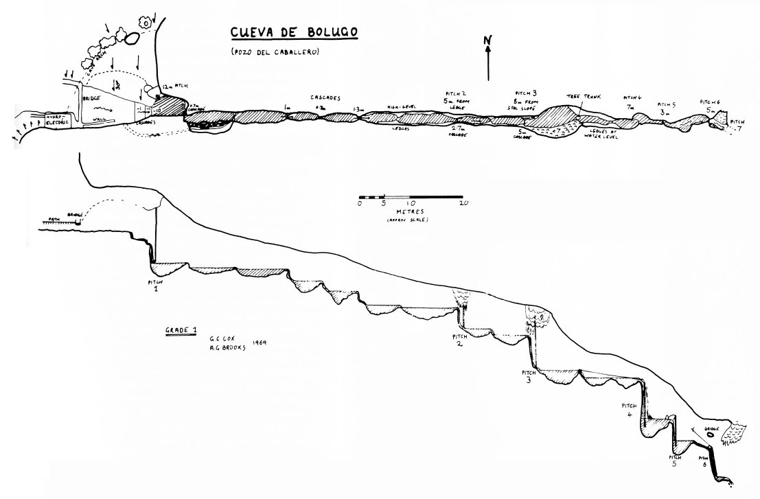
G J M Dare Cueva de Bolugo survey: High; Medium: Low resolution
This cave, familiarly known to the expedition as the Pozo del Caballero, lies in an ideal site for a cave, at the very bottom of a deep blocked valley, providing the only outlet for a very considerable stream which flows into it from the Sierra de Cuera to the west. This stream proved to be an insurmountable obstacle to a thorough exploration of the cave, for the persistently inclement weather swelled it to a size which would have made the the ascent hazardous if not impossible. Part of the stream is used to run a primitive hydro-electric installation in the cave entrance, supplying El Mazuco with lighting.
The location of the cave, below El Mazuco, was already known, for it had been discovered by the 1968 expedition, which had not had time to explore it fully. Consequently it was one of our first objectives. A preliminary reconnaissance made it plain that only a limited trip down would be possible; however, Jim Sheppard and myself, followed by Jon Davies, went as far as the top of the fourth pitch. The entrance pitch is some 15 metres, from beneath the natural arch of the cave down into a deep pool, clearly visible from the surface. It is then necessary to swim across to a narrow submerged ledge in order to untie the lifeline; the passage then consists of a series of small cascades alternating with deep pools which must be swum through. The second and third pitches were little more than steep water chutes, made impassable by the force of the stream. By climbing up to the left suitable rock formations were found on each pitch for hanging a ladder, so that the ladder hung away from the water. This made both take-offs tricky tricky, however. The passage between the third and fourth pitches was notable for a large tree-stump tightly lodged at the top of a cascade - we later made use of this as a belay point.
The fourth pitch was exceedingly wet, being a sheer waterfall of some seven metres, and on this preliminary exploration we decided not to continue further. We optimistically believed that the stream would quickly subside to its normal summer level, a mere trickle; we therefore left the ladders for the second and third pictures on their belays, hung up away from the stream, and came out.
Torrential rain then fell, and the cave was soon in full flood. It was not until the very end of our stay in Spain that we were able to enter the cave again: if nothing else, we wanted our tackle back! A four man party made the descent, comprising Guy Cox, Andy Brooks, Jim Sheppard and myself. We negotiated the first three pitches with comparative ease, and at the top of the fourth we rested to take stock. Jim Sheppard belayed the ladder slightly to the right of the pitch and, with Guy Cox acting as lifeliner, made the descent. Andy and I followed.
As with all the other pitches, the ladder fell into a deep pool, and it was necessary to swim away to the next lip. Immediately we came upon another pitch, a mere three metres deep but with quite a complicated climb around a rock pillar, the belay for the ladder being on the right hand side, on the near side of the pillar. Beyond this fifth pitch was a short passage ending in a long angled pitch. After a long fruitless search we eventually used a belay point high up on the right hand side. Immediately after this, however, was a seventh pitch, with no possibility of a dry belay. The volume of water made it impossible to climb in the waterfall, so here we had to halt.
In drier weather it should be possible to penetrate much further. The cave, as far as we have penetrated, runs more or less due east - directly away from its resurgence. At some point, therefore, it must reverse its direction. The flood resurgence at Caldueñin, 90 m below, terminates upstream and down in a sump. The stream-passage from here to the Vauclusian rising at Cortines has a gentle slope - 50 m in 1 km - and it is probably mostly flooded. It seems likely, therefore, that the cave will descend steeply eastward, following the dip of the rock, until something approaching the -60 m mark is reached, and then turn westward, having a more or less level passage, possibly frequently sumping.