OUCC Proceedings 2 (1963)Dunald Mill Hole |
OUCC Home Page |
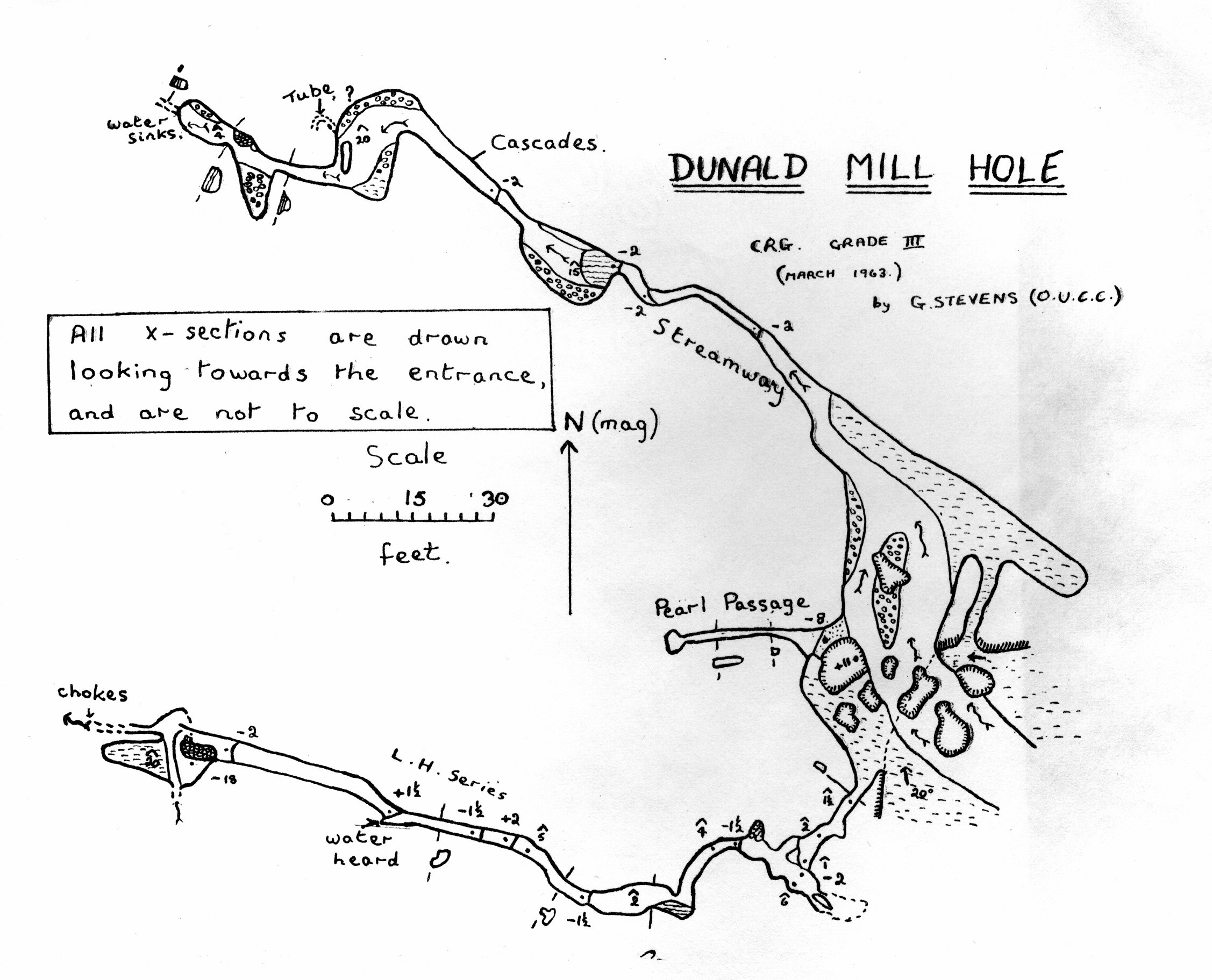
This small cave, which is marked on the O.S. 1" map number 89, is situated in a large depression housing the remains of a corn-mill. A large entrance forms an escarpment at the west end. The cave has been known for many years. One of the earliest descriptions, found as an addendum to West (1) taken from the Annual Register for 1760 was brought to my notice by M.J. Walker and is reprinted in this journal. John Housman (2) in 1800 gives an accurate description of the streamway. A full reprint of this is given by Platten (3), 1952. Another report on the cave is given by Ruthven (4) in Platten's paper. An earlier report by "Northerner" (5), 1942, gives a fairly complete description of the cave, including the left-hand series.
The rest of this article is a brief description to supplement the survey. Three passages lead off from the large entrance. The large stream flows down and into the right-hand side of the arch, and along the Streamway. A large boulder dominates the centre of the archway, and the centre passage leads of from a ledge, behind, but slightly above, the boulder. The left-hand series starts as a low crawl at the left-hand corner of the archway, and is the first passage on descending the soil slope to the entrance.
The Streamway is the most obvious passage; it immediately opens out into a large chamber, which doubles back to the right to the Back Door entrance. Downstream, the width falls to 3-4 feet, and there are some formations on the right wall here. The stream descends a number of cascades to two sharp bends, and a short fall into a chamber with a fairly deep pool. Onwards are more cascades, and soon another chamber is reached. The roof here is over 20 feet high. A partition here splits the stream, which soon reunites to flow under a low arch. In 1960 I remember finding and exploring an ascending sandy tube which choked, starting in the right-hand corner of the chamber. This was not seen during the recent survey programme, so I have only indicated its rough location on the plan. Beyond the low archway is a small chamber with some good flowstone and a Beehive Boss. The stream passes under another low arch to the terminal chamber, and sinks here to the left. A narrow passage continues on, but this has always been full of foam. Flooding seems to occur to a good height in all this passage. A recent rumour has it that a final syphon has been passed by members of the Red Rose Pothole Club, but a report has not yet been seen.
The centre passage commences at a ledge of jammed pebbles, and leads to a squeeze past formations in a narrow rift passage blocked with curtains in places, giving rise to squeezes. The passage widens slightly at the end, and in the roof here are the roots of broken stalactites that must have been at least four inches in diameter. Ten feet back from the end of this passage is a small nest of cave pearls some two inches in diameter. I have some doubts as to the authenticity of the nest, since two pearls appear to be missing. Also similar looking pebbles can be seen at the entrance, and surely the nest would have been robbed by now? The best evidence for the genuine nature of the nest is the cleanliness, compared with the surrounding rock, but the nest is dry. It contained (April 21st, 1963) four pearls, which "fitted" together.
The left-hand series starts as a low crawl to a drop into a chamber. Up the passage, a low passage can be pushed for twelve feet, before withdrawing. Down the passage, a low, tight route with varying amounts of flowstone leads down with a few short drops to the "sink". Here the way is up to the right. At this point the roar of a considerable volume of water can be heard, but no such amounts are known to flow nearby. The sink is not a good dig, being much too narrow. Onwards, the sandy floor gives way to a stream passage, and an eighteen foot pitch is reached. This is an easy climb to the floor of a chamber. A stream, much smaller than the one heard, crosses the chamber from the left to the right, sinking in a pebble-filled passage, which would provide a laborious and probably unrewarding dig.
Ruthven (4) mentions the finding of a chamber with calcite gours and gypsum flowers by the use of hammer and chisel, (see Cullingford (6), 1962), but I find no trace of this. Further work lies in systematic water-tracing, and the "discovery" of other known caves in the area, inadequately described in Pennine Underground. A nearby quarry is rapidly encroaching on the edge of the cave, so a "through trip" may soon be possible.
The survey is claimed as Grade Three. A great deal of care was taken over the readings, over 200 measurements being made for a cave of less than 600 feet, but the grade is dictated on account of the inaccuracies of the instruments. Slopes were measured and corrected for in the plan.
G. Stevens.
(1) West, A. : "A Guide to the Lakes in Cumberland, Westmorland, and Lancashire" Addenda : Article V - "A Description of Dunald-Mill-Hole", 26th August 1760 (London 1793)
(2) Housman, J. "A Topographical Description of Cumberland, Westmorland, and Parts of the West Riding of Yorkshire" (1800)
(3) Platten, G. The British Caver XXIII (1952)
(4) Ruthven Reports ditto XXIII (1952)
(5) "Northerner" ditto IX (1942)
(6) Cullingford ed. "British Caving" p. 179 (2nd. edition, 1962)
See also note in OUCC Proceedings 3.